If we look at the weather predictions it won’t be arctic during the Zurich 2024 road races. However, ice ages were pivotal in creating our parcours. Only a short while ago, geologically speaking, the race course was covered by hundreds of meters of ice. The advancing glaciers and melt water rivers made this course what it is: a challenging race with 2400 meters of elevation for the elite women and no less than 4500 meters of elevation for the men. Together with the Department of Earth and Planetary Sciences at the ETH, the university, in Zürich we look at the geology of the world championships courses.
Ice age
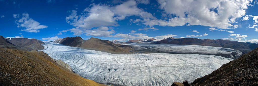
The Winterthur-Zurich area lies in the foreland of the Alpine mountain range. During the so-called Quaternary period, which began about 2.6 million years ago, this region experienced at least 15 significant, rather dramatic environmental changes. The climate fluctuated significantly from warm phases, with yearly average temperatures about 2 °C warmer than today in Switzerland, to very cold glacial periods. In those periods temperatures were 16 °C lower than today. During these glaciations, the Alps were covered with ice. Large valley glaciers flowed downslope from this alpine ice cap, reaching the foreland on both sides of the Alps. They formed extensive so-called piedmont glaciers as you can see in this video.
From cold to hot, and back
Although the Quaternary period was quite short on the geological time scale, it had a huge impact on the morphology of the land surface. During glaciations, the downslope creeping glaciers, together with some gravel, sand and water under the ice, eroded deep, distinctive U-shaped valleys into the Alpine mountain range. In the foreland on the northern side of the Alps relatively soft sedimentary rocks like sandstones are the dominant bedrock type. The piedmont glaciers carved valleys more than 500 meters deep into the bedrock. The bottom of these overdeepened valleys was so deep that it is even below sea level.
Glacial erosion not only made these valleys but also created more features we see in the landscape today like moraines and drumlins by depositing sediments. These are on a much smaller scale than the valleys but very well visible along the course. We highlight them later but investigate their origins first.
Water shapes the land
Were the glacial ice masses alone to ‘blame’ for all the erosion and deposition of sediments? No. During the transition from cold glacial to warm interglacial periods, it was not the ice but large amounts of melt water that was mainly responsible for surface shaping processes. As glaciers melted and retreated, melt water streams could contain large amounts of water. They eroded and incised channels and valleys into the bedrock.
During warm phases between the glaciations, large amounts of rock debris, that accumulated along the glaciers from the Alps down to the foreland, were transported downstream by rivers. It ended up in the valleys of the foreland. Thomas explained this as well in the blog for the time trials. Today, these gravel and sand deposits represent the by far most extracted construction raw material of Switzerland. It is mainly used as aggregates for producing concrete. The gravel infill of the glacial valleys also forms the key groundwater storage type in the Alpine foreland.
Ice, ice baby
Most of the geomorphological traces of the older or less extensive glaciations have been destroyed (eroded) by subsequent glacial advances. The landforms that we can see today are mainly the product of the Latest (youngest) Glacial Maximum (LGM) at around 24’000 years before present. That is geologically speaking like it happened yesterday.
The hills, lakes and valleys of our present-day landscape in the Alpine foreland come from the recent ice ages. Some examples are melt water channels, moraines, drumlins and valleys of which we show some examples later in this blog. That is the visible proof that ice covered the land. They just left their mark for us to see and ride over. But how can we proof that glaciers were once reaching the foreland where we race like we showed in the video? Time to look at the small things. We compare the shapes of the erosional features or deposits. What do they look like? We also look at the material composition of the sediments with features that arise today in glaciated areas. What are they made of?
What we cannot see are the overdeepened valleys, the ones that were sometimes even below sea level. They are filled with erosion products like rock debris, gravel or sand. As Thomas explained they were transprted downstream into the foreland by glaciers and then by rivers. They filled up the valleys that were carved into the bedrock just during the previous glaciation. Imagine that without erosion we could have even steeper climbs.
Landmarks
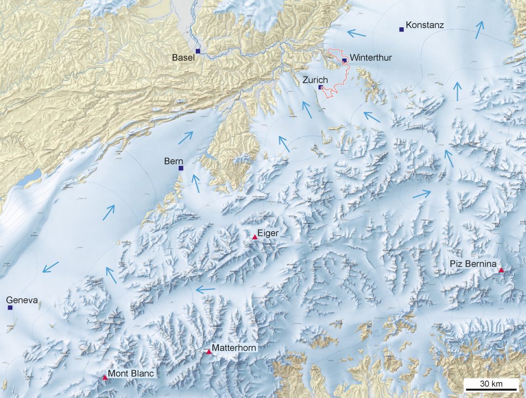
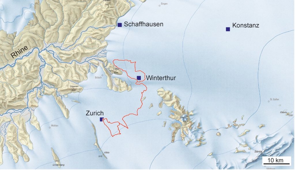
Time to look at some of the recognizable landmarks along the race route. The red line is the men’s road race. The women race the Zurich loop and a loop around the Greifensee. Points 1, 2 and 3 only apply to the elite men’s race. Points 4 to 8 apply to both the men’s and women’s elite races.

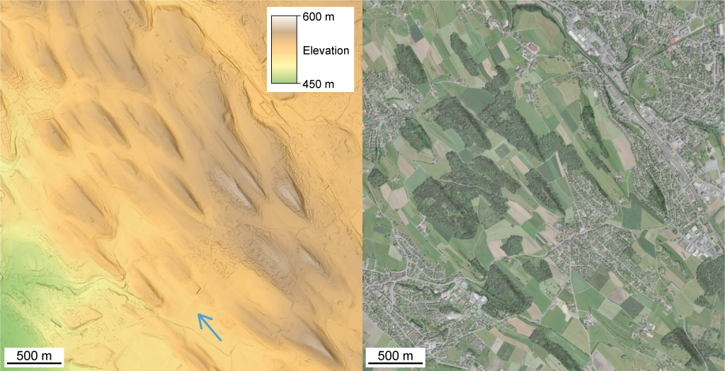
1. Drumlins
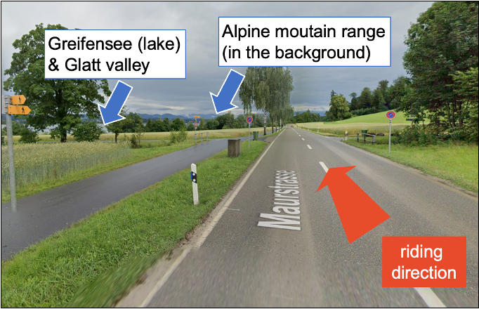
We find these on the men’s course only, on the Winterthur loop – see map below. Drumlin is an Irish term for “little ridge”. These ridges are elongated, oval-shaped hills often occurring in groups. The drumlins in the north of Winterthur and in the Glatt Valley area are about 500 meters long, 100 meters wide and 20-25 meters high.
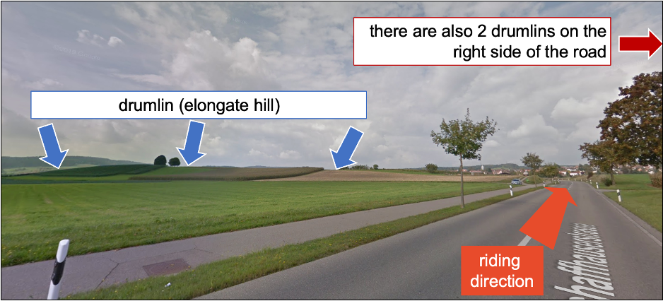
The drumlins’ long axis indicates the direction in which the glacier was moving. These hills often have a steeper face against the ice flow direction. Drumlins probably developed through the interaction of the ice with the underlying unconsolidated ground moraine sediments. However, glaciologists still discuss their exact origins.
2. Irchel mountain – a nuntak or a tafelberg?
On the northwestern edge of the Winterthur loop of the men’s race we find our next feature. The Irchel – number 2 on the map below – has a significant morphology with a flat, very slightly northwest dipping top at 670-695 meters above sea level. It has steep flanks on all sides. It therefore stands out from the terrain by about 250-300 meters. From its shape it looks like a tafelberg. But the Irchel’s origin is multifold.
The flat top marks a former landsurface, at which glaciofluvial gravels were deposited by melt water streams after one of the first glaciations in the Quaternary period ca. 2 million years ago. The Irchel is famous for datable mammal fossils found in interglacial sediments on the hill top that represent a key age evidence for these early Quaternary glaciations.
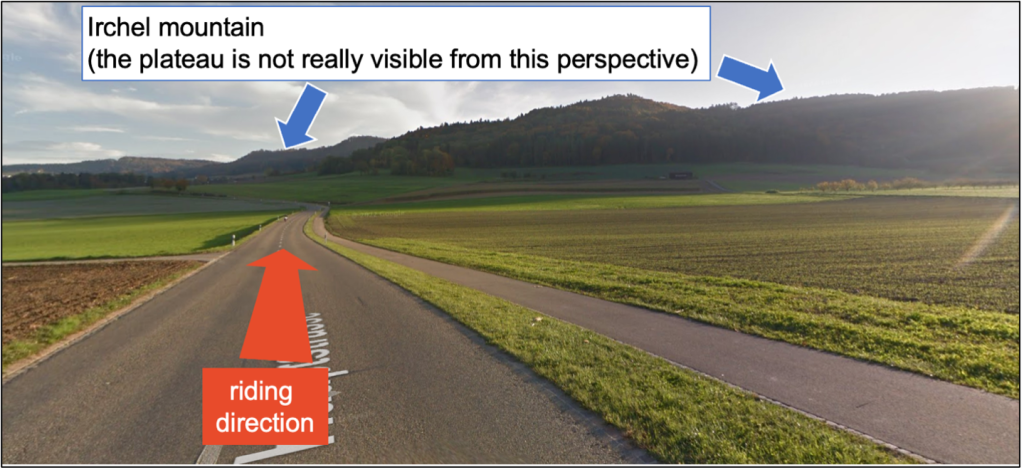
Ice masses of later glaciations hardly reached the Irchel top, but eroded the surrounding area like we explained before. This makes the Irchel a nunatak which is a mountain protruding the ice masses like an island in a sea of ice.
How slow?
Knowing comparatively much about the local glacial and fluvials deposits and processes makes this area very valuable for estimating the amount and speed of erosion. We use that speed for example for the planning of a deep geological repository for nuclear waste that Thomas wrote about. Such an underground repository has to be built deep enough that it will remain protected from erosion for up to 1 million years.
So how do we measure erosion? With the relative incision of the land surface by ca. 370-450 meters since the early Quaternary, we can derive a rate for the erosion by rivers and glaciers yielding 0.14-0.22 mm per year. This is an important measure for such a longterm process.
Time to look at some more features along the course.
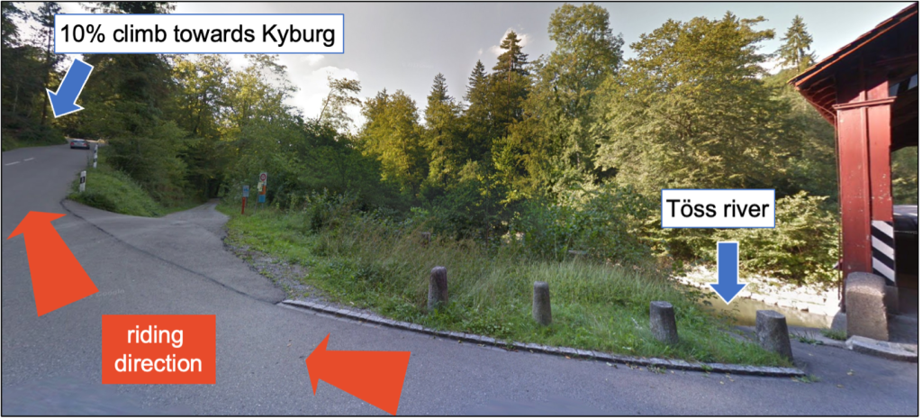
3. Tösstal – Kyburg
The road climbs 150 meters here over one an half kilometers. The average gradient is 10%. The steep hill slope was formed by the glacial melt waters of the river Töss eroding relatively fast into the bedrock.
4. Glatt Valley
We find the plain of the (overdeepened) Glatt Valley when the men’s elite peloton leaves Winterthur to ride south to the Zurich loop. We find two lakes, the Greifensee and Pfäffikersee, in this ca. five kilometer wide valley. They represent remnants of larger melt water lakes that developed after the last retreat of the glaciers. Besides the famous drumlins further upstream in the Wetzikon area, the valley surface exhibits little prominent landforms. What is special here lies underground.
Scientists did many drillings for research or geothermal exploration. They could reconstruct that there is a deep U-shaped valley carved in the bedrock underneath. It is filled now by post-glaciation fluvial sediments. If such erosional bedrock depressions reach below the local base level (drainage base level, i.e. more or less the average level of the regional bedrock surface) we call them a tunnel valley or overdeepened valley.
Locally, like in the case of the Lake Constance, the overdeepened valley in the bedrock underneath can reach below sea level. Overdeepenings are present in many previously glaciated areas in large variety of settings in mountainous areas and their forelands. The formation processes is still a point of discussion. Most likely, glacial carving in combination with fluvial erosion, so in short ice and melt water, play a key role.
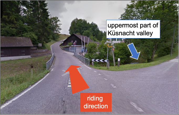
5. Küsnacht Valley
This depression is part of the upper Küsnacht valley, along the lake. It is the result of river erosion into the sandstone bedrock. The area is known for the Küsnacht Bentonite. This is a rare, very fine-grained soft rock derived from volcanic ash. It was deposited 15 million years ago after a volcanic eruption in nearby southern Germany (Hegau volcanic field).
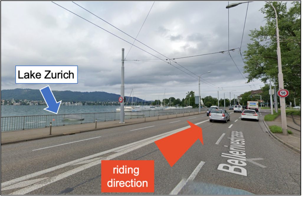
6. Lake Zurich
Lake Zurich represents one the many periglacial lakes in Switzerland that formed during the last glaciation period about 14.000 years ago. The 140 meter deep lake is located on a glacially overdeepened valley. It was eroded by glaciers another 150 meters into the bedrock.
7. Terminal moraine in Zurich
After the Last Glacial Maximum, ice masses started to melt and the glaciers retreated towards the Alps. This took place not in one single process, but during several melting and retreating phases. Warm, cold, warm, cold. Between these phases, the glaciers came to a halt (standstill phase) for some years. During such a standstill phase, some time between 15’000 and 19’000 years ago, the terminal moraine of Zurich was formed. Today it’s in the city’s old town. Best known remnant of this moraine is the 20 meter high Lindenhof hill. There are traces of inhabitation from at least 4’500 years BC (Neolithic period). It documents celtic and roman activites.
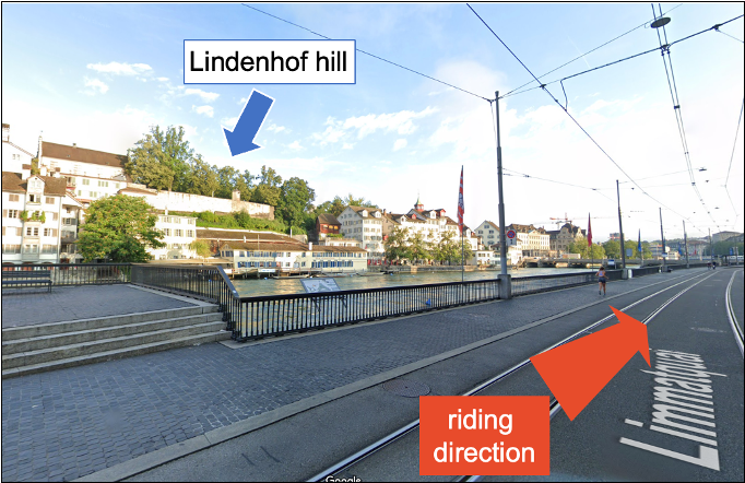
After the renewed melting of the ice, the melt water was damned by the Zurich terminal moraine and formed Lake Zurich. It had nowhere to go. The large record of drilling data due to construction activities in the city document a layer containing very special, chaotic sediments. These sediments indicate that a catastrophic event must have occurred.
Investigations of lake bottom sediments have shown that around 14’000 years ago, there were lake-wide underwater debris flows that were presumably triggered by an earthquake. That earthquake, or alternatively a large rock fall into the lake (back then reaching much higher upstream towards the edge of the Alps), induced a huge tsunami-like wave that locally destroyed the daming moraine and leading to this outburst.
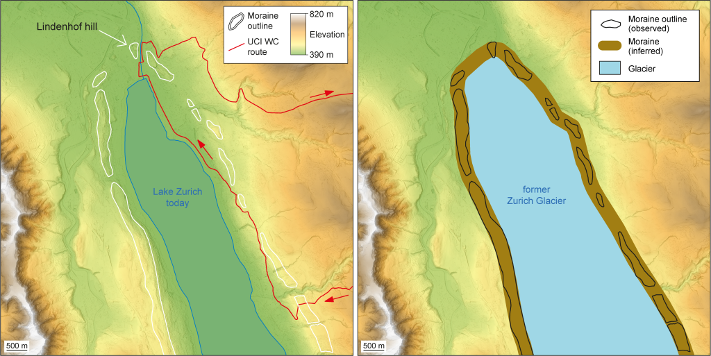
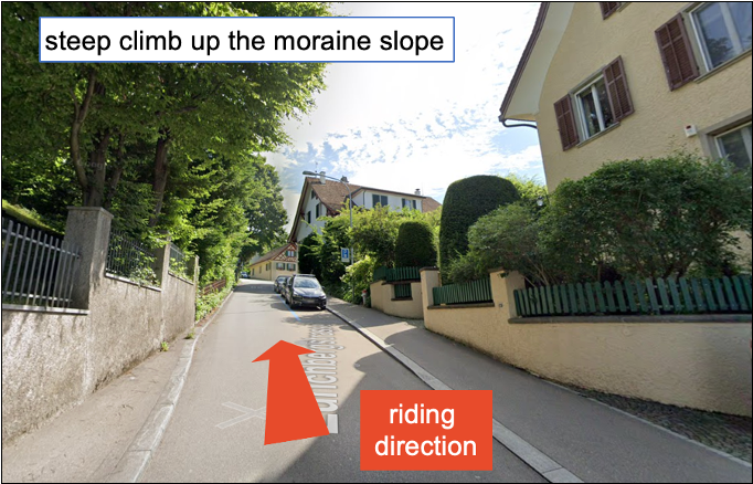
8. Zürichberg
The riders climb up a more than 12% steep moraine slope here. The glacial deposits are only a few meters thin. The slope is actually defined by the bedrock valley that resulted from the erosions of multiple phases of glaciations.
This blog was auto-translated from English. Any language mistakes are not the author’s.