
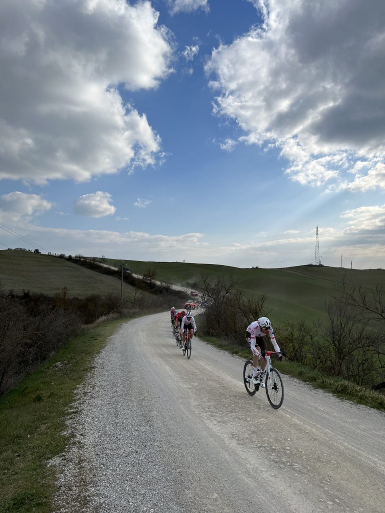
On today’s stage nine of the Tour de France it’s all about gravel. The stage starts and finishes in Troyes. The town hosts picturesque gothic cathedrals overlooking the cobbled streets but we won’t go into the geology of cobbles now. I will leave that to Paris-Roubaix times. Troyes is the historical capital of the Champagne-Ardennes region. It is well known for its famous vineyards, interspersed with white chalk roads. That’s what I want to talk about because it’s all about the gravel.
The World Tour peloton knows the terrain already because Paris – Tours, a late season classic, has been raced over the tracks of the vineyards in recent years. Also, perhaps more famously, Strade Bianche and its sterrato have given the peloton experience on the looser surfaces. I aim to take you on a journey through time of how the gravel of the area of today’s stage came to be. Maybe it can be used to understand the technical challenges the riders face specifically on this stage due to the geological conditions. Riders and sports directors, are you listening?
More limestone? Yes more limestone but today we race on it! Gravel is limestone.
What is gravel
First we need to have the definition clear before we go on the gravel stage. Gravel is defined as a loose aggregation of rock fragments. It generally occurs in a variety of shapes, sizes and colors depending on the weathering processes, or the erosion, involved in forming the fragments. The original rock composition is of course also a defining factor.
Simply stated, gravel is a collection of sediments that are over two millimeters in diameter. It can have either a rounded or angular edge. Whilst there is no upper limit in size for gravel, this article will focus on small gravel under 20 milimeters in diameter to make it as applicable to the race as possible. The bigger stuff is great for driveways and gardening, or the occasional flat tyre, but it’s not the gravel we find in the vineyards around Troyes.
The devil is in the sea level
So where do we find Troyes in the grand scheme of geological history, and why did it become such a great place for gravel racing?

It has been an uplifting journey for the city of Troyes, if you pardon the pun! Much of what we now call France had remained intact until recently, geologically speaking. Some 300 million years ago, the whole of the Earth’s continental land mass was joined into one supercontinent, named Pangea. Pangea was big and cold, and a large icecap existed on the South Pole.
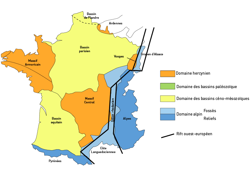
Within this, France was positioned closely between the modern-day UK, Germany, Spain and Italy, similarly to the present. Although it was in a very different location to modern-day Western Europe. During this period, rocks were deformed into a big mountain belt. These rocks were then eroded, and deep, crystalline portions of the mountain belt came to the surface. By 250 million years ago, the mountain belt had been eroded almost flat, and the deformed crystalline rocks were lying at the Earth’s surface. You can still see this surface not far south of the Champagne region, in the Massif Central.
Break up
Then, Pangea began to break up. The Central Atlantic Ocean started to form, and also in the Indian and Southern Ocean, continental breakup started. The result was that plate tectonic activity nearly doubled. In the heydays of the late Jurassic to early Cretaceous period, around 150-100 million years ago, the rate of oceanic crust production was almost twice as high as during Pangea, and as today. With such high crust production, also the rate of crust removal by subduction was much higher, and as a result, the average age of the ocean floor became younger and younger.
Why is that important? Well, the depth of an oceanic basin is depending on it! The younger the ocean floor, the shallower the ocean. Moreover, with higher plate tectonic activity, there’s also more volcanism, and more volcanic CO2 production (three times as much as today). With higher CO2 production, temperatures were much higher. The land ice melted. So the oceans were not only shallower, there was also more ocean water than today. And as a result, the continents around the oceans flooded. France drowned below a ~200 m higher sea level than today. And that’s the beginning of today’s gravel stage!
You need limestone
In tropical seas of no more than a few 100 meters deep, limestones form. Limestone is a sedimentary rock that is made up by calcium carbonate as the main minerals. Fun fact: it fizzes when diluted acid is dropped onto it. Limestone often holds fossils of marine sea creatures such as coccoliths and foraminifera. These make up chalk. The limestone therefore holds a geological record of the past conditions of France under the sea.
The sedimentary chalk base that underlies much of France was formed during the Jurassic to Cretaceous period, roughly 150-80 million years ago. Dinosaurs still roamed the earth back then. Sedimentary rocks are generally formed in marine environments, as Troyes was during this time. So we are talking mostly sea lizards and dinosaurs in this part of the world.

There are two types of limestone surrounding Troyes. There is Courville limestone and the Savonnières limestone. Both have been heavily quarried over time for construction purposes. Courville is a stone local to Reims, whereas the Savonnières is from slightly further afield, about 100 kilometres east of Troyes.
Whilst similar, there are some key differences between the two stone types. The ages of the two stones are different. Courville stems from the Eocene (50 million years old) and Savonnieres from the Tithonian (150 million years old). That makes it an older rock by roughly 100 million years. These rocks are made of chunks. They are 17% and 29% porous respectively, which offers good drainage, aiding both grape farming (as you read on stage 7) and bike racing!
Race geology
In the Champagne region, sedimentary rocks are 75% limestone. This stuff is hard, porous, and brittle. So, the rocks are durable, but break easily into pieces. So if you gotta make a road in this region, who needs pavement? The subsurface does the job just fine! OK, it’s not quite the Strade Bianche. Those white Tuscan roads sit on a geological surface of marble, which is the noble, hard, expensive white rock that you’d form if you take the limestones of the Champagne and you’d bury them at 20 km depth in a mountain belt for a few million years. But the white roads of today are made up of the same calcium carbonate! It’s good to know that the Strade Bianche marble gravel is far smoother of a surface, with fine, rounded material instead of the stony tracks of Champagne.
So, today’s gravel stage will likely be more difficult in the corners than Strade. The material in France will be looser and less compact due to its bigger size. Finer material when wet compacts more (remember the Van Der Waals forces you learned in high school? They’re acting on these smaller sand sized sediments). Larger material is less clastic, so even when wet it is still loose. Rain has a significant impact on limestone gravel due to its chemical composition, which can cause it to dissolve in bad weather, creating a soft and sludgy road for the riders. This could result in the gravel sectors closer resembling a cyclocross race rather than Le Tour de France! Hello Mathieu, Wout, and Tom!
NB: Blogs in other languages than English are all auto-translated. Our writers are not responsible for any language and spelling mistakes.
