
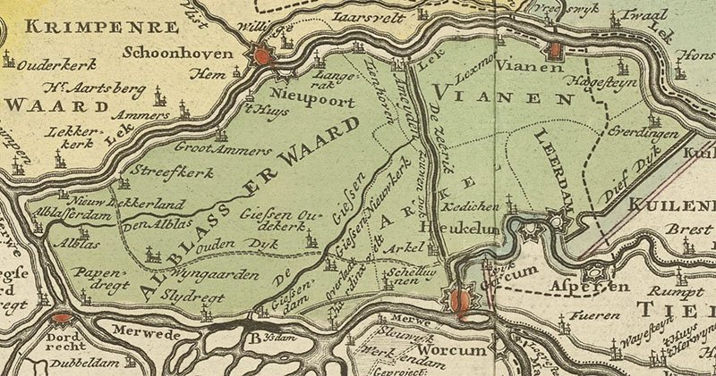
Three large tidal channels in the Rhine-Meuse mouth region of Dordrecht and Rotterdam in the South of Holland feature on stage two of the Tour de France Femmes. It is not only river branches that cut up the Netherlands. It is also the dykes along them. Crossing rivers also means crossing dykes. Crossing over to a next river means traveling through a polder: a flood protected, water managed area in economic use. We will put two polders in the spotlight today: after the first river bridge, the stage goes through the iconic polder Albasserwaard. After the second river crossing we will pass through the IJsselmonde polder.
What made these old polders and their dike rims so strong? The tidal sediment underneath. What allowed failed Medieval polders lost to storm surges and inundation heal and recover? Tidal sedimentation again. What brought in the sediment? The river and its tides.
Famous polders
The Netherlands has many polders. Some of these polders are super famous and iconic because they are low-lying. A long history of water management is boasted to have kept them ‘dry’. Today’s Alblasserwaard with the Kinderdijk Unesco site is a prime example. The race will pass it in the first 30 kilometer of the stage.
Polders are man-managed compartmented areas in deltas and coastal plains. Dykes around and ditch networks inside these areas make that inside polders, water levels are kept below where they would be naturally. The dykes also help to keep river water out of the polder. The ditch networks of the polder route water to some exit point, where one purges it into the river.

The famous polder of Alblasserwaard features today but also te slightly overlooked one called IJsselmonde, literally translated as ‘mouth of the Ijssel’. The Polder IJsselmonde is such an overbuilt (population: about 400,000) polder. The stages passes it the second half of the stage.
Ebb and flood
The Netherlands has many polders, but in between all these polders are just as many separating rivers. Where we ride today, not that far inland from the North Sea, these rivers are tidal. Their water levels go up and down twice a day, because of their connection to the open sea. At Rotterdam, the keen observer will see the river switch flow direction twice daily. It’s ebb when seawards with lowering water levels and then flood when landwards with rising water levels.
Further inland near Dordrecht, it is not flow reversal between ebb and flood, but stalling of flow at flood and acceleration at ebb. In both places, fresh water river outflow floats on top of incursing tongues of marine waters (because more salty = denser = heavier). Historically one could drink from the rivers, Rotterdam was about the last place downstream where that was possible. Access to sufficient potable water is important to river mouth water towns. Tides stalling river fresh waters and making it mix with sea water to turn it brackish, also does funny things with sedimentation it turns out.
Tidal mud makes good homes
The murky moving tidal waters also carry abundant fine sediment. Especially at high water, when flow stalls and tides turn, mud in the water has good chance to settle over flooded bank and shoal areas. Slimy algae and diatoms on the daily flooding mud banks help stick the mud once settled. Patriotic colonizing plant species tolerant to a splash of mud and a pinch of salt now and then, help trap more mud. Some, like samphire are quite edible, others like reed were traditionally quite useful for roofing. Brief areal exposure during low tidal phases dries the mud and helps consolidating it.
This whole ensemble trapped a lot of sediment along the banks of the tidal rivers and made them higher: to spring tide high waters and a bit above, about two meters above mean sea-level easily, about a meter above regular high tide. The resulting high ground of the tidal river banks was very nice for people wanting to settle along tidal rivers. Prehistorically, the setting allowed to combine marine fishing with a bit of local farming, doing some trade and keep plenty offspring alive. Into historic time, the setting allowed for further economic development, urbanism, global trade and industrialization.
Build a city – use the tidal mud
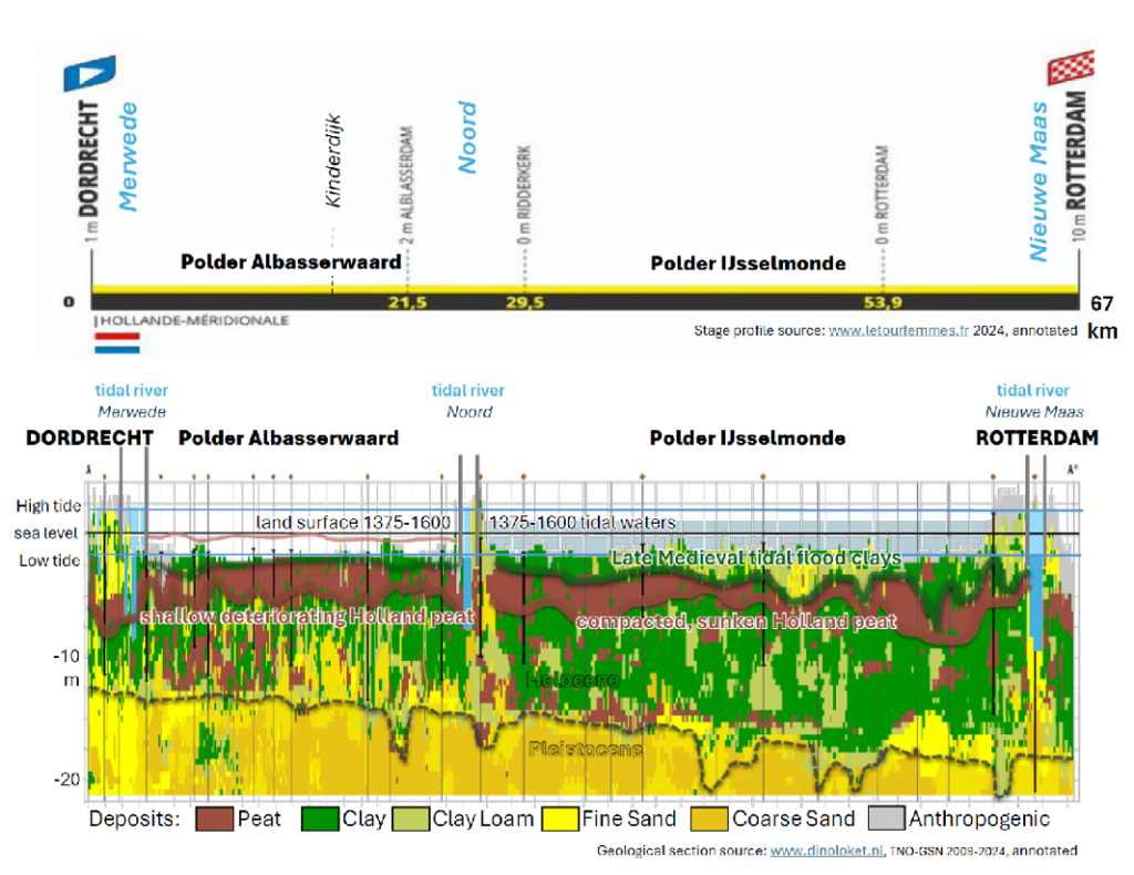
Let’s take a look at the geological section of today’s stage above. At the begin and the end, one sees Dordrecht and Rotterdam both built on stacks of tidal muds of the banks of their respective rivers. We measure some two to four meters of it. This overlies a compacted peat bed of a few 1000 years old aptly called Holland peat. Below that one finds even more tidal deposition from earlier phases of Holocene delta and coastal plain build up.
One has to dig or erode to over 15 meters below the tidal river banks, to encounter sandy Pleistocene substrate geology. Piles driven down as foundations for high rising buildings, as well as deep local scours at susceptible locations in the tidal waters do that. To the geology of the stage of today however, really only the upper tidal deposits and the first layer of peat matter.
Now, spoiler alert, there is a big caveat to the tidal geological city settlement success story. It is only narrow zones – a ribbon some 100 meters wide – where natural tidal sedimentation really provides space to dwell along rivers. The rest of the land in between rivers was less elevated and if it was it was boggy and soggy. Sediment was trapped on the river bank. You cannot eat the cake twice: far less of it reached the interior between the rivers, leaving just water and plants to arrange for deposition. Hence the Holland peat bed is so wide spread.
Build a dyke -reclaim the land
This lasted until river bank societies had enough of it. Successful river communities quite rapidly ran out of space, pushing them to venture into less suitable grounds away from the river that were not blessed with tidal mud. It tricked the Dutch to start massive reclamations of delta plain areas of dark peaty shallow geology. It was decided to upgrade the tidal bank natural levees, raise them a bit more artificially and call that dykes.

Like the river banks, the dykes encircle the peaty inlands, that now could be exploited as polders. Ditch networks were laid out to drain their boggy interiors and cultivate the land. This was a success as long as dykes stopped spring tides (once every fortnight) and storm tides (a few times per year). You also need to keep river and polder separated, and route excess rain and groundwater out of the polder compartment. Bring on the windmill to create the polder!
The Ablasserwaard polder
In the Polder Alblasserwaard we see the result of bold Medieval reclamation that was rolled out between 1100 and 1250 CE. We also see 800 years of further adaptation and maintenance to make the polder stand the time. Looking carefully at the section above, one sees that Holland peat covered by a thin cap of fluvial-tidal clay. The position where we find this surface now is 1-2 meters below mean sea level. It is very close to low-water level in the tidal rivers. Originally, the polder land was higher elevated, closer to high-water level in the tidal rivers. A position for ca. 1375-1600 is indicated in the cross-section, well above present surface. There is a relation between the steady lowering of the land and the tidal rivers to which the polder drained.
When the ditches were fresh, no form of pumping or milling waters out of the polder up into the river was needed. One could simply make use of repeating low tide situations and let water freely flow out the polder using a culvert through the dyke. Such culverts had a gate that opened itself at low tide letting polder water out, and closed at high tide preventing river water in. The problem was that when polder groundwater levels lowered, peat dried out and got exposed to the air, making it loose volume (no more water in its pores) and mass (carbon oxidizing to CO2) and critically: elevation. As the polder surface sank, free flow and low tide culvert drainage was less and less effective and the lowered land turned soggy again.
Windmills and dry feet
From the 1600s onwards windmills turning Archimedes screws were used to heave polder waters up in basins called ‘bossoms’ along the edge of the polders. From there it was than released into the river at low tide, as before. This led to the water management system conserved at Kinderdijk. From the 1800s onwards, steam, diesel-electric and electric pumps replaced the windmills, with greater capacity than before, accelerating the land subsidence and increasing the CO2 emission.
So far, this Medieval polder reclamation has survived the growing land subsidence problems. Persistent water management and innovating wit and skill regarding pumping systems and dyke security can be put forward to have accomplished this an engineering success. Just as much though, it is the relative inland position of this polder and strength of the tidal banks around the polder that allowed this polder to survive. Those circumstances can be framed as geological success. With every decade, though, the subsiding polder is coming closer to its expiration date. For now, cyclists can still enjoy it. Given sea-level rise: don’t ask, don’t tell for 2100.
The IJsselmonde polder
The second polder of the stage wasn’t as big of a success. The substrate and Medieval reclamation history are quite comparable to the first polder but the longevity of the reclamation was not. Also here peaty land between embanked tidal rivers was eagerly reclaimed by digging networks of ditches between 1100 and 1200. The dykes around the polder, however, frequently breached. Especially between 1373 and 1424 the old polder became majorly tidal inundated owing to a series of storm surges (1373, 1374, 1375, 1421, 1424 ) and large river floods (1374, 1422). The Polder IJsselmonde was just 200 years old. This was a Medieval fail and the former peat land became tidally inundated space. Reason of the fail? The more exposed westward position and the higher storm surge wave impacts experienced along their dykes probably.

The geological cross-section (image 3) shows a much thicker clay and clay loam than in the first polder. These are tidal sediments from the period 1375-1600 mainly, from when the polder was under water twice daily. The load of the tidal deposits has caused compaction and sinking of the peat below, allowing the tidal deposits to accumulate a bit more. From their towns on the ridges between river and drowned polder, humans eagerly observed the silting up process.
Soon as tidal sedimentation allowed it, new small dykes were put on the emerging salt marsh to reclaim the lost polder bit-by-bit. This started in the east in the 1430s, and would take until about 1600 to be completed for this polder, again a time frame of just 200 years. Pretty fast geological healing, tidal deposition can be very efficient.
Tidal living in the future
The story of Medieval fail and loss, but healing by tidal sedimentation and allowing for a new round of reclamation of the same area, now with even better soil than originally – is not unique to the Polder IJsselmonde. Southeast of Dordrecht a good part of another 1421-24 lost polder has been reclaimed in the same way. We discover the Biesbosch in this video.
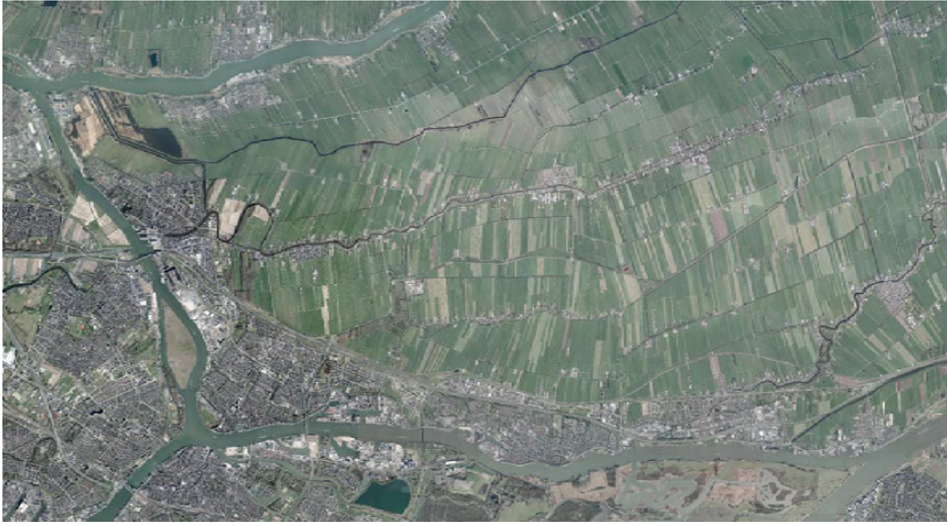
If we evaluate management and sustainability challenges for Medievally failed polders like IJsselmonde, the prospects are better than for surviving counterparts. The tidal sediment cover has compacted the peaty substrate and pushed it to greater depth. This makes it less susceptible to oxidation and present-day land subsidence than the Albasserwaard.
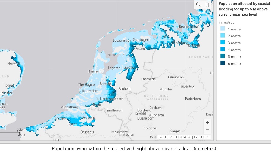
It is much easier and cheaper to turn a polder with tidal deposits in the topsoil to urban area than to do so for one with peaty substrate. Watching the stage on television and comparing areal photos in this blog will demonstrate the cities of Dordrecht and Rotterdam to have indeed done this massively. Still, one or two meters of sea-level rise and tidal amplification associated to the deepening of the tidal rivers will also put these polder lands for adaptation and land use function survival challenges in the upcoming centuries.