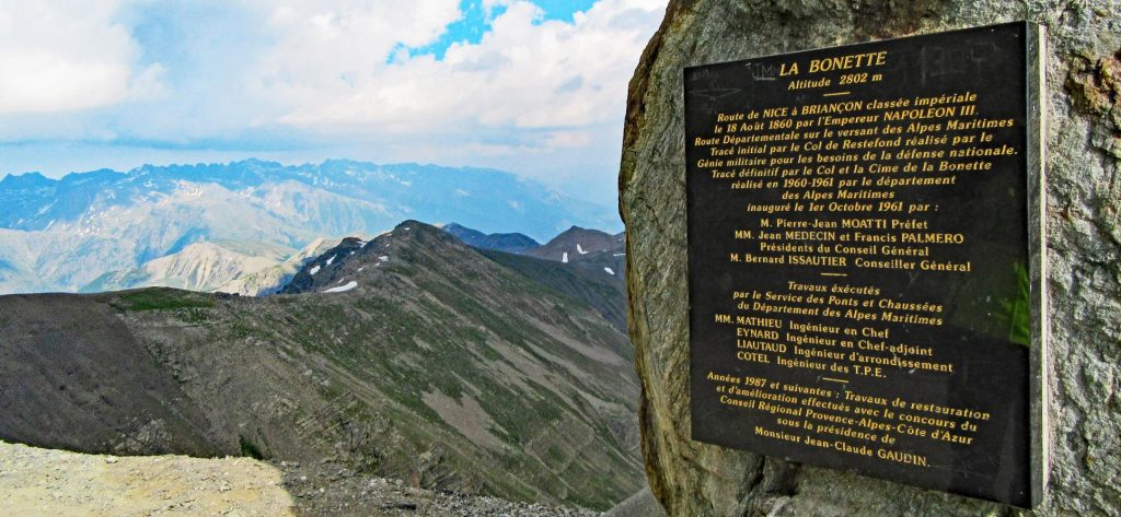
Today’s question is how high is high? Today’s stage 19 has special significance because it crosses the highest point of the year. It’s called the Cime de la Bonette. The rider who crosses the top first gets the Souvenir Henri Desgrange. Even more special is that the Cime de la Bonette is the highest road a Grand Tour ever went. This year is the fifth time since the 1960s. The Tour de France lists its elevation as 2802 meters, as does the plaque at the top. Yet Strava segments ending at the top have maximum elevations ranging from 2750 to 2802 meters. Google Earth has an elevation of about 2806 meters.
How can that be? Why is the Bonette so high? And how high is high? How do we know the elevation of mountain passes, and what do we really mean when we say elevation? This post will dive – or climb – into the topics of elevation measurement and geodesy to investigate those questions.
Why are the Alps so high?
Major mountain ranges like the Alps form where tectonic plates collide causing the crust to become thicker. The crust and lithosphere of the Earth floats on the underlying mantle much like an iceberg floats on the sea. This concept is called isostasy. We told you this yesterday too but repetition is always good.
Continental crust, like in the Alps, is less dense than the mantle beneath it so it buoyantly floats on top. Major mountain ranges exist where continental crust is thicker, causing the top of the floating crust to be higher. Think of that iceberg yesterday. We call the deep, thick continental crust beneath major mountain ranges a crustal root. By measuring the pull of gravity, geoscientists have imaged the deep, low-density crustal root that supports the Alps. Perhaps the sprinters should blame the Alps’ crustal root, not just the ASO, for their suffering on the mountain passes.

How high is high?
Two of the most common methods for measuring elevation are GNSS and barometric altimetry. GNSS refers to GPS, run by the USA, as well as the systems operated by the EEU (Galileo), Russians (GLONASS), and some other countries. Smartphones and bicycle computers use GNSS to determine elevations and locations. GNSS systems have sets of satellites that transmit signals.
Standard GNSS devices use signals from four or more satellites to trilaterate their position usually to 1 to 10 meters of accuracy. Heights relative to the center of the Earth are readily calculated because the satellites orbit the Earth’s center of mass. More sophisticated systems use differential GNSS to get accuracies down to a few millimeters. These high-accuracy instruments are now approaching the size of a postage stamp, so perhaps we’ll soon have them in our bicycle computers and we can all make super accurate measurements of the Cime de la Bonette.

Pressure
Many bicycle computers and sport watches also have a barometric altimeter to measure elevation. They work by measuring air pressure and converting that to an altitude. This is possible because air pressure decreases dramatically with altitude. These devices can detect an elevation change of just a meter or two. To calculate altitude from the pressure they use a generic set of values for air pressure from sea level to high altitude called a standard atmosphere.
Air pressure at sea level averages 1013 mb. On the Bonette, air pressure will only be about 720 mb. The spectators at the Bonette will be gasping for breath when they run along with the riders. Remember, please don’t touch the riders. They also suffer enough in the thin air to get the watts out.

The problem with barometric altimetry is that the atmosphere often differs a bit from the standard atmosphere. This can lead to elevations being off by over 100 m, so altimeters are very precise yet inaccurate. Some devices combine GNSS and altimeter measurements to reduce this problem. The inaccurate segment elevations in Strava mentioned at the top of this post probably suffer from this issue. I am sorry if you did less meters of elevation than your computer indicated. It’s the pressure that got to it.
What is elevation?
To find out how high is high we need to answer a basic question. What is elevation? Usually, elevation refers to a vertical distance above sea level. That has clear meaning near the coast like on the Passage du Gois. But what does it mean in the Alps? As a starting point, scientists and GPS devices approximate sea level under the land surface using an ellipsoid. The ellipsoid follows a smooth, average sea level elevation around the globe.

Imagine if the continents were crisscrossed by deep canals that were filled in by the oceans; the surface of the water would lie along the ellipsoid. The shape is an ellipsoid and not a sphere because the Earth spins on its axis once a day. The centrifugal force makes its diameter 42.769 kilometers larger at the equator than the poles. Measurement of the ellipsoid and other aspects of the Earth’s size, shape, and gravity is called geodesy. Today a single ellipsoid, the GRS-80 (the WGS84 ellipsoid is virtually identical), is widely used and is accurate to centimeters or better. Most smart phones and bicycle computers report elevation as the distance above (or below) that ellipsoid.
It’s dense
The ellipsoid assumes that the density of the Earth does not vary from place to place but as we saw at the beginning of this post, it does. Where denser rocks are present underground in the Earth’s mantle and crust, they create stronger gravity. The stronger gravity pulls water towards the area (or would do so if no land were in the way). That creates a bulge in the water, raising sea level.
On the other hand, sea level is lower over less dense areas. To account for that, geodesists have estimated the geoid. The geoid deviates up and down by up to about 100 meters from the ellipsoid to account for the density variations within the Earth. The denser the Earth, the higher the geoid. In that way, it provides a more accurate estimate of sea level globally.

At the Cime de la Bonette, the geoid is 54,3 meters above the ellipsoid. Its 2802 meter elevation is relative to the geoid. Elevations relative to the geoid are more accurate but many small devices use only the ellipsoid. A device that does incorporate a geoid will often report elevations 10 to 50 meters different from one that bases elevations off the ellipsoid. Yet another reason elevations for a climb can be so varied.
Thank you, geoid
What if we didn’t use an ellipsoid or geoid? If elevation were measured as the distance from the center of the Earth, the elevations of some of the highest roads in Europe would look quite different relative to each other. Below is a list of what the elevations would be, relative to Cime de la Bonette. Sea level elevation is the method we use normally, and is the one we explained in this blog.
Elevations’ of some famous passes as distances from the center of the Earth. In the right column, negative numbers indicate the pass is lower, or closer to Earth’s center, than the Bonette. Passes further to the south rank higher due to the ellipsoidal bulging of the Earth at the equator.
| Summit | Sea level elevation (m) | Distance from the Earth’s center (km) | Distance from Earth’s Center Relative to Cime de la Bonette (m) |
| Cime de la Bonette | 2802 | 6370.545 | 0 |
| Col du Tourmalet | 2118 | 6370.387 | 2367 |
| Col de l’Iseran | 2764 | 6370.098 | -455 |
| Col du Galibier | 2624 | 6370.090 | -455 |
| Passo dello Stelvio | 2762 | 6369.681 | -864 |
How far is far?
Finally, geodesy even affects how we measure stage lengths. French scientists were at the forefront of geodesy during the Renaissance. In the 1790s, they set out to carefully measure the distance from Dunkirk to Montjuic near Barcelona. From this, they estimated the shape of the ellipsoid and the distance from the North Pole to the Equator through Paris. The length of a meter was then officially defined to be one-ten-millionth of that distance. The official meter is being kept at the International Bureau of Weights and Measures in Sèvres, France.
Stage 19 will cross the highest point in this year’s Tour de France, and one of the highest roads in Europe. Without geodesy, we wouldn’t really know how high the Bonette is. Geodesy also gave us the length of a meter. Not just the elevations of the passes in the Tour depend on it but also the way we measure the stage lengths do. There simply is no Tour de France without science. That is basically the entire idea behind GeoTDF in a nutshell.
NB: Blogs in other languages than English are all auto-translated. Our writers are not responsible for any language and spelling mistakes.

