Today the race traverses through the scenic volcanic field of Chaîne des Puys where we raced in 2023 as well. These volcanoes erupted periodically between ~90,000 and ~8,500 years ago forming the landforms you see today. This volcanic field is currently considered extinct. However, for today’s blog post, let’s consider if there was to be an eruption in the future. Let’s take the Extreme Weather Protocol to the very extreme and look into a fiery future.

Where?
The Chaîne des Puys is a 40-kilometre-long monogenetic volcanic field. Monogenetic volcanoes are small and short-lived volcanoes. Hence, once they erupt, their life comes to an end. Looking at the photo of Chaîne des Puys above, you can see that there are many cone-shaped features spread across the volcanic landscape. In fact, Chaîne des Puys has an impressive 80 volcanic cones. These locations mark where the magma erupted during past events. The close proximity of these volcanic cones means that pyroclastic ejecta from an eruption of one vent sometimes covered others. They then formed a complex array of overlapping layers (also see second figure below).
If we map and look at the spatial density of these cones, as has been done in other places such as the Bolaven Volcanic Field, Laos (Verolino et al., 2022) or Snake River Plain, Idaho (Gallant et al., 2018), it could give us an indication of where future activity might occur. This is difficult as it assumes magma will ascend through the same systems as past events, that nothing changes. In reality, activity may migrate through time. However, looking at figure 2 below, the features generally follow the North-South rift system that runs parallel with the Limange fault. Past activity has followed this pattern. Last year we explained why we have volcanic activity right here.

Learn from the past
Next in our philosophical thinking experiment into a fiery future is to determine what kind of volcanic hazards we can expect?
To look at what possible eruptions might be like, we need to look back at the types of volcanic activity that happened here in the past. We can forecast the future from the past, as so often in science. The basalt to trachyte lavas (see figure 2 above) indicate a range of eruptive styles and provide distinct landforms. For example, the past eruptions ~90,000 and ~8,500 years ago, formed basaltic and trachytic cinder cones, basaltic maars, and trachytic lava domes, across the landscape. In 2023 Douwe van Hinsbergen visited the site.
Small pieces of solid lava that piled up around the vent during an explosive eruption, formed cinder cones. Maars are large volcanic craters formed by explosions usually caused when magma heats groundwater. They often fill with water to form lakes. Lava domes are lava flows that are too thick to flow away from the vent. Activity fluctuated between more explosive activity producing cinder cones, maars, and ash fall, and more effusive activity producing lava domes and flows.
Lava on course
Whilst ash fall blankets topography indiscriminately, lava flows follow the topography of previous volcanic activity. The lava flow deposits can teach us about how lava interacts with local topography. One such lava flow, emplaced ~41,000 years ago in the Tiretaine valley, followed the 2020 race route (figure 3). During this eruption, lava erupted in the vicinity of the Petit Puy de Dôme.

Initially, it flowed as smooth pāhoehoe lava across relatively flat topography at maximum thicknesses of ~50 m. Later as it travelled downhill it transitioned into a more rocky a’ā lava channel and filled the valley at the bottom of the slope where the flow ponded and cooled (figure 4). The flow extended right out to ~7 km, underlying Clermont Ferrand city today. Outcrops can be seen along the race route.

Disaster management
Typically when we assess how many people are at risk of potential volcanic eruptions, we look at how many people are living within certain distances away from the volcanic crater. However, Chaîne des Puys is a volcanic field. This makes it difficult to do this as there are multiple craters. However, estimates from the Global Volcanism Program for this area indicate that ~300,000 people reside within 10 km and ~1.5 million people reside within 100 km away from the volcano.
Around the world, some monogenetic volcanic fields are located very close to highly populated areas. For example the city of Auckland, New Zealand is located on top of the Auckland Volcanic Field with 53 cones dispersed throughout the city (GeoNet). The southern part of México City is located on deposits of Chichinautzin volcanic field eruptions (Torres et al., 2023). This means that if there is an eruption, it is uncertain where exactly it will occur, but it will likely have large-scale impacts on the cities.

For Chaîne des Puys there are lots of important assets in the nearby region. An eruption would also have large consequences. Since the Iron and Roman Ages, the region has been significant for civilization, through farming and agricultural practices. Since 1960, there has been urban expansion onto the edges of the volcanic field. For example, the city of Clermont Ferrand is ~7 km to the east of the volcanic field. Local cities rely on the hydrological system of the volcanic range for drinking water. Tourism is also significant to the area. The cathedral is even made of volcanic rock.
What ifs
We already established that the volcanoes here are considered to be extinct. Such a relief. However…let’s explore what potential impacts a volcanic eruption would have on the bike race? And how bikes can help you evacuate quicker.
If there is an explosive eruption, this may produce an ash fall which will reduce visibility for the cyclists, and for the viewers at home. Vehicles stirring the ash would worsen the visibility, and so vehicle lights will be barely visible. Riders will need to wear face masks as inhaling fine ash into the lungs can cause coughing and irritation. Fine grained ash will damage the bikes, as it infiltrates openings, corrodes paintwork, and scratches surfaces. At less than 1 mm ash thickness, those yellow arrows indicating the race route will be obscured. The riders would also not be able see their bike computers anymore as ash covers the screen.
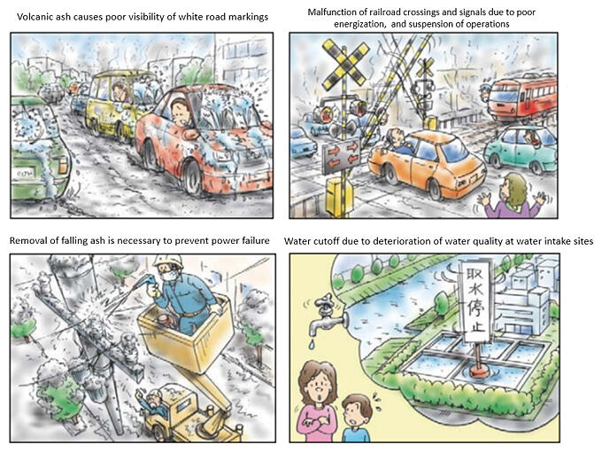
Through time the ash layer on the road will thicken as more is deposited. Up to 50 mm, there will be a loss of traction of vehicles. Up to 150 mm, the ash will cause abrasion to the road and there will likely be road closures as it becomes impossible to traverse (read more in Wilson et al., 2012). It is particularly difficult to steer or pedal uphill in ash. Let’s just not continue the Tour de France in the case of a volcanic eruption. That’s the kind of fiery future the Extreme Weather Protocol should be clear on.
Save the bikes!
Despite these challenges, bicycles have been used or planned as a method of evacuation from eruptions. Interestingly is that the impacts from the 1815 Tambora eruption in Indonesia are claimed to have sparked the invention of the bicycle as The Times reported.

However, if we were to deal with real lava, things might be a problem? Well, technically no. There was very fast lava in 1977 at the Nyiragongo volcano in the Democratic Republic of Congo. It flowed up to 60 kilometers an hour! That’s even too fast for Filippo Ganna but on average and particularly on shallow slopes, lava flows travel at an average of 1 km per hour (source). Yes the roads would be inundated eventually but the peloton would be able to quickly evacuate and the race could continue!
NB: Blogs in other languages than English are all auto-translated. Our writers are not responsible for any language and spelling mistakes.
