
Today the peloton rides through the heart of the Paris Basin. It will be as close to Paris as we will get this year. But what? A basin! The Paris area does not really look like a basin, does it? Well, in geology a basin is where sediments were deposited for millions of years. Basins accumulate sediments of various ages and compositions, based on climate conditions.
These basins are ideal for geoscientists to study, and for cyclists to ride on top of. The history is literally below their wheels. But do we write history on the bike too today? We don’t have that expertise here so let’s continue on the Paris Basin and its history.
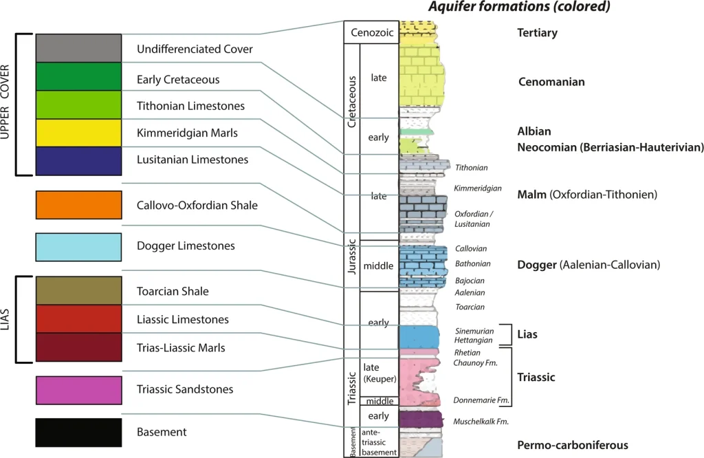
Basins generally fill with horizontal, quite even sheets of sediment. That makes them flat as a pancake. Great day for the fast men of the peloton. We time travel from the start in Orléans where we have the youngest sediments from the Miocene. In Saint Amand Montrond the stage finishes in the Lower Jurassic at the surface. During this stage the riders do a transect through the entire stratigraphy of the Paris Basin from young to old. For the ease of telling the history of these rocks, and how they were formed through time, we start with the oldest history and work our way up through time. Let’s time travel through the Paris Basin!

Quick history lesson
The history of the Paris Basin starts some 250 million years ago at the boundary between the Permian-Triassic periods. This was at the time of the Pangea supercontinent. Most of the world’s continents were still fused together. North America was attached to Europe. There was no Atlantic Ocean yet. Between 250-180 million years ago this was about to change. The supercontinent started to break apart. Geologists call this intra-continental rifting. This was quite similar to the present-day East African rift zone, from Ethiopia to Mozambique, where eastern Africa is rifting from the rest of the African continent. In that rift zone, the continent starts to thin, sink and eventually drift apart.
The European-North American continent was in a relatively hot and arid desert environment, with occasional volcanism and dispersed lakes. These lakes became deeper over time. Eventually these rift lakes merged, fresh water was replaced by saline water, and the Atlantic Ocean was formed. Gradually it extended further north and south over the next 180 million years. At present the Atlantic Ocean is still spreading by several centimetres/year. This makes flights or boat trips between Europe and North America slightly longer every year.
A basin is born
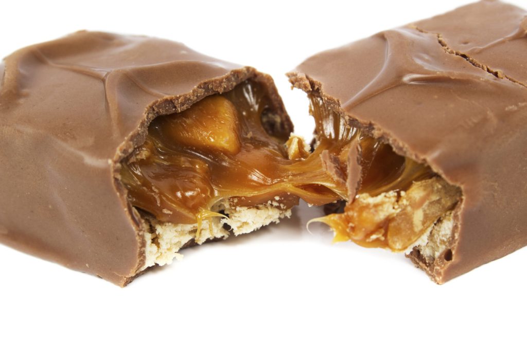
During spreading, the continental crust and the mantle thin. The brittle crust on top breaks, whereas the viscous mantle stretches. On this candy bar above the chocolate breaks and the chewy caramel stretches. As part of the break-up mantle rocks (with some less dense magma being formed), get shallower than the surrounding mantle material. After some million years, the mantle and magma solidify again and gets heavier.
This results in the whole area subsiding. You get a saucer-shaped depression in the landscape. The Paris Basin was born! Hurray. From 180 million years ago, so throughout the Jurassic and Cretaceous, sediments accumulated in this basin. This is because sediments, transported by rivers and seas, always seek the lower parts of the world. Nature eventually fills up these natural depressions with sediment.
The basin through time
We have witnessed the birth of the Paris-Basin but what happened next? The sea came in! The basin itself sunk and the global mean sea levels rose. This is the time where we find marine sediments. The first marine sediments were early Jurassic (Lias). They were mud-prone and deposited in an oxygen-free sea of a few hundred metres deep. These conditions resulted in the deposition of organic-rich sediment, rich in tiny algae fossils. We call these rocks the ‘Schistes Cartons’. You find rocks of this age near the finish in Saint Amand-Montrond.
Fun fact: In the centre of the Paris Basin, around the city Paris, these rocks were buried deeper. It resulted in oil being generated. The centre of the Paris basin has been producing oil since at least mid-20th century, albeit in relatively limited quantities. It’s not exactly the Texas of Europe, so to say.

In the middle-upper Jurassic the basin became somewhat shallower, maybe due to filling up of the basin, or a reduced amount of sea level rising. Organisms created limestones on extensive carbonate platforms. These rocks are part of the Dogger Formation and are buried beneath the landscape of Bruer Ali-Champs to Bourges.
After this, the basin was being compressed from the south due to tectonics leading to the Pyrenees, happening from the Cretaceous onwards. In parts of the basin deposition stopped and/or started to erode the already deposited sediments. Relative sea level was therefore low. Preserved sedimentation in the Lower Cretaceous was relatively minor and mostly clastic like gravel, sand and silt. This was great news for stage 9.
The bathtub effect
In the later Cretaceous (from 100 to 60 million years ago) the basin became much deeper again. As a result of global sea level rise (read more), thick chalk layers of a different kind of limestone formed by deepwater plankton fossils called coccolithophores appear. At the time, global mean sea level was much higher than today. This was due to two things. Earth itself had a warmer climate.
Secondly there were no polar ice caps. This led to ~70m higher sea level. In addition, there was more plate tectonic activity with plate spreading in the Atlantic, Indian, and Pacific oceans. When oceanic plates spread, they form mid-oceanic ridges (~2.5km water depth on average), which are shallower than older oceanic crust (4-5 km water depth).

When more plate spreading occurs, oceans are on average shallower and can store less water. With more water available because there are no ice caps and less storage volume because of shallower oceans, all the excess water had to go somewhere. Like over-filling a bathtub, water was flowing over the edge onto the continents. The water covered land.
Large parts of Europe were therefore covered by a relatively deep sea, resulting in widespread chalk deposition. These iconic white deposits are well known from the coasts of both Dover in the UK, but also from the shores of France in the Boulonnais region. This is effectively the western edge of the Paris Basin. In this stage, the peloton may catch a glimpse of them during the crossing of the river near Vierzon, where they incise into these upper Cretaceous rocks. It shows how varied the geology of the Paris Basin is.
Modern use
Hominids started inhabiting France (see stage 12) and used the land. In our times we do the same. We use the specific geological characteristics of the Paris Basin, like the oil reserves in Paris. But we also use the Paris Basin for more sustainable energy. The Cretaceous limestones mentioned above act as aquifers. That means water-bearing rock units used as a source of ground water. Currently, scientists study the aquifers under Orléans to use as a source of geothermal energy. We see this also in the Netherlands on stage two of the Tour de France Femmes so do come back to the site later.
In short. In the earth, temperature is increasing with depth, as a result of the closer proximity to the hot mantle and ultimately the hot core. On average temperatures increase ~30°C/km in earth’s crust. This provides a sustainable source of geothermal energy. Typically, to tap the geothermal energy, a doublet of two wells is drilled, with cold water being pumped down. The cold water heats up by the warm rocks. Warm water is pumped up again to surface. At present geothermal energy is already being tapped in Paris for decades and the potential is being studied for Orléans.
Food production
Since the end of the Cretaceous (66 million years ago), there has been relatively less sedimentation in the Paris Basin. In part this is due to the ongoing compression by the Iberian plate from the south, with the Pyrenees and partial uplift of the Paris Basin as a result. Additionally, since the Cretaceous, plate tectonic activity decreased, leading to deeper oceans and cooling of the Earth’s climate. Subsequently this led to formation of ice caps and the lowering of global sea level.

The Paris basin became more continental and accumulated deposits from rivers. Although most of these were clastics (sand, silt, etc.), some limestones were deposited in big lake environments. At the start in Orléans, limestones of Oligo-Miocene age called Beauce limestones were excavated for centuries in large underground mines. Aside from being a source of building materials, these caves were also re-purposed for storing wine, food, and growing chicory because of the ideal growing conditions. It’s dark, the temperature is low and it has constant humidity. In World War II, people sought refuge in these caves.
Today we race here, on a rather easy stage. That is if we don’t get a repeat of the echelon chaos in 2013 when we also raced to Saint Amand Montrond. Today’s stage might be just calm but below the surface there are millions and millions of years of development. Isn’t that fascinating?
NB: Blogs in other languages than English are all auto-translated. Our writers are not responsible for any language and spelling mistakes.
