In the only true Dutch spring classic, riders enjoy the beautiful scenery of South Limburg during the Amstel Gold Race. The region is known for its hills. This makes it very suitable for a cycling race! Besides these differences in altitude, which are particularly large for the Netherlands and result in many sore legs, the region is also known for its beautiful geology. From the oldest exposed geological formations to marine limestones and green sands, wind-blown Löss deposits, the Amstel Gold Race has it all! And on top of that, there’s the fierce climbs up the staircase of Maas terraces to (hopefully) heaven at the finish! This is the geology of the Amstel Gold Race.
After the start in Maastricht, the first 15 kilometres take you across the terraces of the Maas valley. The first climb even has the name Maasberg. The geological history of the Maas (or Meuse in French) will play an important role in this race. The Amstel Gold race’s winding course sends the riders up the staircase of Maas river terraces. The landscape resembles a staircase because it is characterized by relatively flat sections separated by short but steep slopes. But what exactly are “river terraces” and why do they dominate the Amstel Gold Race?
Stairway to heaven
Rivers shape landscapes through erosion and deposition of sediments. Erosion occurs when flowing water wears away rocks and soil, while deposition occurs when sediment carried by the water settles. These processes form elements such as sand and gravel bars, river banks and floodplains. When a river cuts into the surrounding landscape, it leaves behind an abandoned river plain. We call them river terraces.
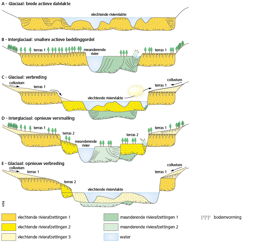
In general, during the cold ice ages of the last two million years, the Maas formed a broad, braided river plain consisting mainly of sand and gravel. Natural climate cycles led to a change in river discharge and an increase in cover vegetation. This resulted in reduced sediment supply. As a result, the river pattern of the Maas underwent changes to a meandering form during the warmer periods between the ice ages. It is mainly during these warm interglacials that the river incised, leaving behind the sand- and gravel-rich glacial river plain of the previous glacial as a river terrace. Terrace. Incision. New terrace. Incising again. Then you get a staircase shape.
However, this alternation between glacials and interglacials alone is not sufficient to explain the 31 (!) terrace levels in southern Limburg. We need another geological process to get to this large series of river terraces. We continue with the geology of the Amstel Gold Race going back a couple of million years more.
Road bump ahead!
Between kilometres 22 and 27, the riders cross one of the largest fractures in the Netherlands’ subsoil. This is the Heerlerheide fault and is part of the Feldbiss fault system. It is now a small bump but used to be infamous for its many disturbances in underground coal mining.
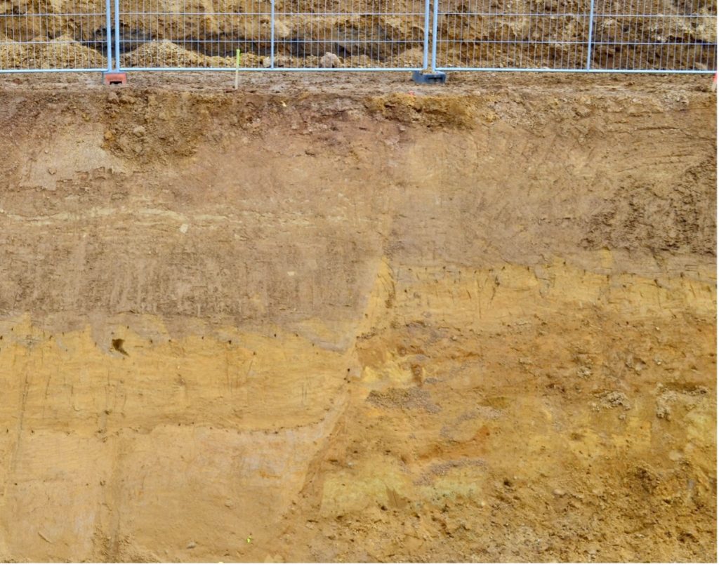
The Feldbiss fault system has been around for a while (about 6 million years ago) and is still active. It occasionally causes earthquakes in southern Limburg and surrounding areas. The most famous of these is the Roermond earthquake of 1992. It had a magnitude of 5.8 on the Richter scale!
Easy does it
Vrije Universiteit Amsterdam has dug a trench across the Heerleheide fault at kilometre 22 to see if the fault has been active in the recent past. Fortunately, that is not the case so the course can continue. For now.
The continuous, though very slow, upward movement through the fault system combined with the alternation of glacial and interglacial periods is, especially since the beginning of the Pleistocene (2.58 million years ago) important not only for the formation of river terraces, but also for their preservation. It is this unique combination that resulted in the 31 river terraces of the Meuse in southern Limburg. As the riders approach Elsloo, they will encounter the first step: the Maasberg and many more will follow.
Critters
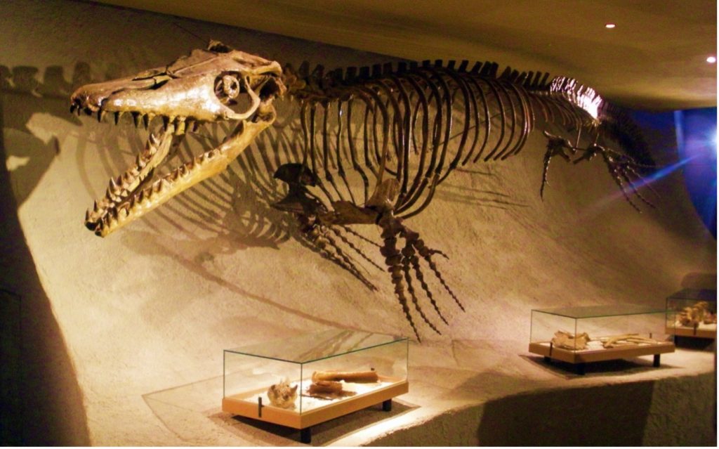
As the riders turn west at Nijswiller after 56 kilometres, they cross the Geul valley on their way to the Margraten plateau. This relatively flat area is geologically known for its limestone. In this area, the relatively soft and (very) fine-grained (Gulpen Formation) and younger sandy limestones (Maastricht Formation), known in Limburg as marl, are present close to the surface (although often covered by a thin layer of gravel from the Maasterraces). These limestones were formed in a marine environment during the Maastrichtian (72.1-66 million years ago). They are famous for their fossil content, with the Mosasaurus being a well-known highlight. This is not a dinosaur but a lizard. In this video, we tell you how.
Flowers
After 107 kilometres, we are at the Geul near Epen. During the nature break, there is an opportunity to pick the famous bright yellow zinc violet. Disclaimer: don’t do this. It’s illegal. We have this zinc violet due to the large quantities of heavy metals, such as zinc and lead, and other filth that were dumped into the Geul during the lead and zinc mining industry.
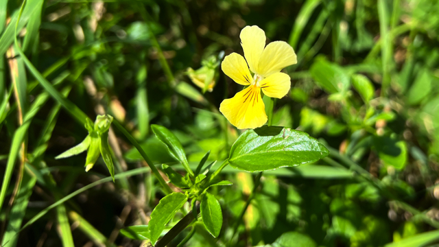
This has been going on since the Middle Ages at Plombiere (the name says it all!) and Moresnet. Originally, this mining was very profitable. Because Prussia (now Germany) and the Netherlands (Belgium was not yet independent) could not agree where the profits should go, that area was an independent state for more than a century, from 1816 to 1918. Mini state “Moresnet”, like a kind of Monaco! But the ore is now no longer extractable and “Moresnet” was dissolved. The last lead mine closed in 1922. They even turned it into a monument!
Geological hotspot
Some 120 kilometres from the line, we cross the Geul once more at Epen. Near this location, we find the oldest exposed geological formation in the Netherlands. Indeed, the geological hotspot in the abandoned Heimansgroeve gives a wonderful insight into the Carboniferous. On display here are sandstones and shales from the Epen Formation, which were deposited 326 to 313 million years ago in a shallow sea in which sand and clay settled.
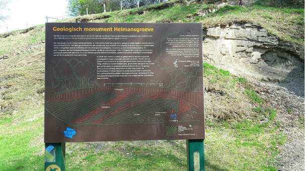
You can see small brachiopods (Lingula) and burial marks in the sandstone layers. These layers are -geologically speaking- slightly older than the deposition of thicker, and formerly coal mined, coal layers. Unfortunately, the sign posted in the quarry for clarification is incorrect. The creators of the sign did not see the fold, and perhaps mistook the well-developed pressure splitting in the shale for sedimentary layers, and it says more incorrectly. Wikipedia gets it right, though! The fold was formed during varistic orogeny, a period of mountain formation roughly 300 +/- 40 million years ago when the supercontinents Gondwana and Laurussia collided to form an even larger continent, Pangea.
The biggest geology events on a global scale return in the geology of the Amstel Gold Race. That’s what makes it all so fascinating.
Highlight
It is from this point deep back in time that, after riding through Vijlen to Vaals, the climb to the top of the Vaalserberg staircase begins. This three-country point brings the riders up about 140 altitude metres to not only the highest point in (the European part of) the Netherlands at 322,4 metres, but also the three-country point between the Netherlands, Belgium and Germany.
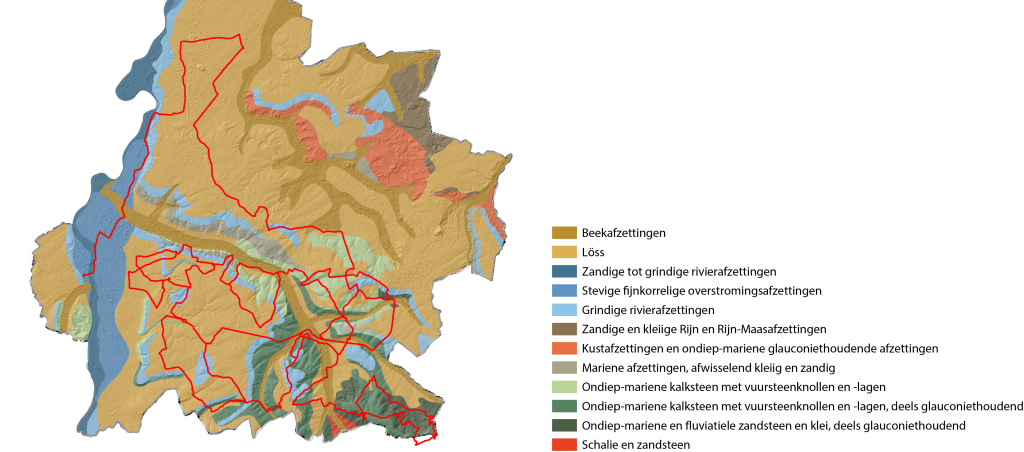
Moreover, it is in this region that the Vaals Formation is present at or close to the surface. These glauconitic green sands and clayey sandstones were formed in a shallow marine environment during the late Cretaceous and are generally covered in the rest of southern Limburg by the younger limestones of the Gulpen and Maastricht Formations, which makes it extra special to be able to see the Vaals Formation deposits in the outcrops along the hairpin bends of the climb. But whether the riders have an eye for it? We hope we can surprise you viewers with this knowledge, though.
Cauberg
At 81 kilometres from the line, we go up the Cauberg for the first time. There we climb up a thick layer of the Meerssen limestone cut through with cave systems. The Limburgers prefer to speak of ‘groeve’, so the municipal cave has the name Valkenburgergroeve. Consider also the Sibbegrubbe (groeve).
We also find löss (as in Paris-Roubaix). This is a characteristic wind-blown deposit of mainly silt formed during the ice ages. During these periods, the North Sea was dry because much of the water was stored in extensive land ice occurrences. In addition, there was almost no vegetation cover during these cold periods which facilitated transport of the fine silt fraction by the wind to the higher South Limburg. This blanket of löss was deposited almost all over southern Limburg and, especially in the lee of the river valleys, is sometimes up to 10 metres thick. The löss deposits therefore partly cover the height differences between the river terraces of the Maas, sometimes giving them a more gentle slope than originally. This is a pity then. Just short of Angliru on the flanks of the Cauberg.
Building blocks
We find around the Cauberg a limestone package relatively free of flint nodule layers, which made the soft, porous limestone relatively easy for the marl sawyers to cut into blocks. They have been doing this since 1500. If you drive through South Limburg’s hilly countryside, you see buildings and farms constructed from those limestone blocks everywhere. Those blocks seem far too soft to build houses with. But once you build with them, the blocks become increasingly solid.
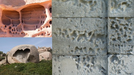
When rain fills the limestone with water, some of the lime in the pore water dissolves. That water moves to the surface of the block, where the water evaporates and the lime precipitates and fills the pores. So they gradually get stronger but the inside then remains brittle. So you should not make holes on the surface otherwise you will hollow out the block from the inside. This kind of weathering has a name: tafoni weathering.
Far away meteor
In the finale, we do the Geulhemmerberg twice. Unsuspecting, near the house in the cave, the riders pass a small level between two limestone layers, between the Meerssen limestone and the Geulhem limestone. This reflects an event that completely turned the world upside down 66 million years ago. The giant Chicxulub meteorite impact in Mexico then put an end to the realm of dinosaurs and mosasaurs, paving the way for the ancestors of the sweaty pedallers. In this clip, you can see this thin layer that had such a huge impact geologically-historically. Without that meteor, we might never have evolved into humans on two wheels on Geulhemmerberg.

Finally
The finale also includes the Bemelerberg twice, which is also part of the Maas terraces. Here again, the beautiful Maastricht chalk and the deposits of the Maas can be admired. Hopefully, the riders can enjoy the fascinating geology the Amstel Gold Race. This is race a cycling classic with a golden geological edge through the beautiful South Limburg landscape. Maybe you can one day return for a ride yourself and marvel at its geological treasures.
Marjolein explains how a tropical sea led to the building blocks of the houses along the course. She also found a sea beast……
