It is time for the last big cycling race of the year. That means time for the geology of the 117th edition of Il Lombardia! Its nickname is La classica delle foglie morte (the classic of the falling (literally: dead) leaves). The race is one of the oldest and most prestigious races of the year. It is one of the five ‘Monuments’ of cycling. The landscapes that the riders will race through are much older though! So let’s zoom in on the fascinating geology of one of the most beautiful regions of Europe, right at the southern edge of the Alps. Get ready for the geology of Il Lombardia.
A lost continent
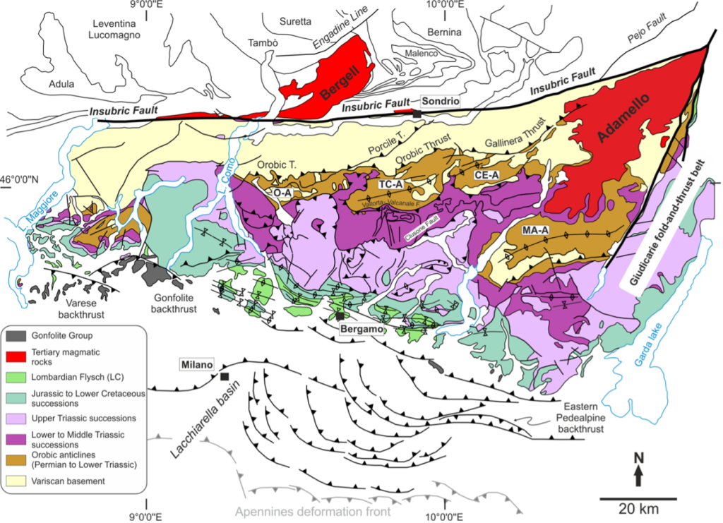
This year, Il Lombardia starts in Como. It’s the city that gave its name to the world-famous, Y-shaped Lake Como. Coming from the south, the first mountains of the Alps rise up impressively from the completely flat Po Plain. Unsurprisingly, we refer to this part of the Alps as the Southern Alps. The (Southern) Alps formed as a result of the collision between Europe and the continent of Adria. This process is Alpine orogeny. Check this video where Douwe explains orogeny using cheese.
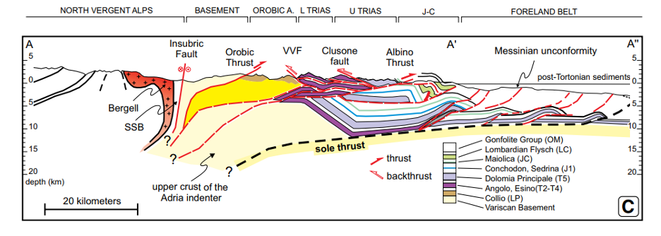
The Southern Alps are separated from the rest of the Alps by a major fault. This is the Insubric Fault (see figure). It has been active since at least the Oligocene (~30 million years ago). The rocks of this part of the Southern Alps mostly consist of Triassic to Cenozoic sediments. Think of limestone and dolomite that formed in the shallow seas on the passive margin of the former – now lost – continent of Greater Adria. The only visible remnants of this ‘lost’ continent – about the size of Greenland – are now preserved in the mountain ranges of countries like Italy, Croatia, Greece, and Turkey.

Deep Lake Como
The mountains of the Southern Alps are dissected by deep river and glacial valleys. Some of which host the world-famous lakes of northern Italy, such as Lake Como. The Huffington Post called Lago di Como the most beautiful lake in the world. George Clooney felt so impressed by the scenery that he bought a house at the lake. It is currently for sale for the small price of 107 million euros…
So how did these lakes form? Given the current subtropical microclimate at Lake Como, it may surprise you that the north Italian lakes have a glacial origin! During the last ice ages, large glaciers carved their way through the mountains towards the south. After the glaciers retreated at the end of the last ice age, this deep valley filled with water. This resulted in the 3rd largest lake of Italy. Over 400 meters deep, Lake Como is the 5th deepest lake of Europe. It is the deepest outside of Norway. The U-shaped valley looks like an Italian version of a Norwegian fjord!

Left: Picture of the Triassic Limestones surrounding fjord-like Lake Como (taken by Bram Vaes near Lecco). Right: reconstructed lobes of the glaciers that carved the glacial valleys that now host Lago Maggiore and Lago di Como. From Note Illustrative della Carta Geologica d’Italia Foglio 075 Como.
And its monsters…….
The most famous inhabitant of Lake Como has strong ties to geology. The Lariosauro, named after the old name of the lake (Lario), is a mythical monster that supposedly lives in the lake. In 1946, a reptile-like creature was supposedly seen swimming the lake. This created Italy’s version of the famous myth of the monster of Loch Ness. Since then, there have been multiple alleged sightings of the Lariosauro. Its existence has obviously never been proven.
Interestingly, swimming reptiles actually used to live in the area! During the Triassic Period, 70-80 cm-long reptiles, actually called Lariosaurus by paleontologists, were living in the tropical sea that once covered this region. Discovered already in 1830, this small – and hardly frightening – ‘monster’ was one of the earliest studied reptiles of the Alps. Many fossils of this small, carnivorous reptile were found in the impressive mountains of Triassic limestones near Lecco. This year’s race passes right through these mountains.

Feed zone
After 149 km, the riders pass the small town of San Pellegrino Terme. Famous for its thermal waters, San Pellegrino has its origins in the ancient settlement of the Orobi people. This ws a Celtic ethnic group. The water from San Pellegrino is naturally rich in minerals. This is thanks to its origins in the Dolomite peaks at approximately 1200 meters above sea level. It takes around 30 years to travel more than 800 meters in altitude and reach the source at San Pellegrino Terme. During this slow journey, it absorbs minerals of the dolomite and volcanic rocks it flows through. That gives the water its beneficial properties.
Mineral water has been produced in the town for over 600 years. Leonardi da Vinci is said to have visited the town in 1509 to get a taste (pun intended) of its famous water. He even wrote about its properties. In 1961, a bottling plant was established for the famous S. Pellegrino mineral water and other carbonated beverages.
Passo di Ganda
During the last major climb of the day, the Passo di Ganda, the riders traverse one of the sedimentary basins that survived the Alpine orogeny. The rocks deposited in the former basin have not been heavily deformed or metamorphosed. It is the ideal place to study what the area looked like during the age of the dinosaurs! The first section of the climb, from the church of Gazzaniga to the “Masserini” locality, runs through what was once a Triassic carbonate platform formed in a tropical, shallow sea. Today, similar environments can be found in places like the Bahamas.
If you closely look at the limestones along the road, you can even find fossilized remains of ancient corals! More than 200 million years ago, this area was teeming with exotic marine flora and fauna. In 1973, a researcher from the natural history museum of Bergamo discovered the fossilized remains of the world’s oldest pterosaur (~217 million years old). It is called the Eudimorphodon ranzii and was discovered some 3 kilometers south of Gazzaniga in the town of Cene. It was the first flying reptile of the Triassic period! The site is now open to visitors as part of the Paleontological Park of Cene. The fossil itself is preserved at the Enrico Caffi Civic Museum of Natural Sciences in Bergamo, along with other fossils found in the Cene quarry.

Let’s go for a swim
From dinosaurs back to the geology of Il Lombardia. During the most challenging part of the ascent, the riders suddenly find themselves in the actual, ancient sedimentary basin. It’s a relatively low-lying environment where thick packages of sediments were deposited. At the start of the Jurassic period, approximately 200 million years ago, the undisturbed carbonate platform experienced a drastic change. This was caused by the opening of the Atlantic Ocean. Despite being thousands of kilometers away, the separation of Eurasia from North America caused profound changes in the future Alpine region.
A new ocean, known as the Ligurian-Piedmontese Ocean, began to open. It eventually reached the stage of the current Red Sea before coming to an abrupt stop. In fact, upon reaching the summit of the Passo di Ganda, the riders arrive at the foot of the ancient underwater escarpment that outlines the main fault of the basin. It produced numerous underwater earthquakes during its Jurassic activity. This can be seen in the limestones along the road, which offer direct evidence of underwater landslides. In short, we are passing over what was once a very active ocean floor!

Southern Alps natives
The final ascent before arriving in Bergamo traverses one of the hills that characterize the frontal part of the Southern Alps. Like all the climbs of Il Lombardia, these hills are directly related to the collision between Adria and Europe. Remember, the one that led to the uplift of the Alpine chain. The ‘last’ hills of the Alps, formed by the folding of Cretaceous turbidites and Oligocene-Miocene foreland deposits, suddenly disappear to the south. However, the chain does not end there! Geologically speaking, the Southern Alps continue beneath the pancake-flat landscape of the Po Valley.
During many millions of years, the rising Alpine mountains faced erosion by wind, water and ice. The sediments, like sand and clay, that formed during this process have been deposited by rivers like the Po, Ticino and Adda in the Po Basin. They now form a kilometers-thick cover of the southernmost part of the Alps. We call this invisible part of the mountain range the “Milano belt”. A perfect example of the hidden geological world that is located beneath our feet! Or wheels…..

And the winner is…
During the race, most riders will have little time to enjoy the geology and scenery around them. For a few riders though, the landscapes of the Southern Alps will surely make them feel at home. In terms of the geology, there are many similarities between this part of Lombardy and another famous region in cycling: Slovenia. It is therefore not very surprising that the two biggest favorites of this year’s race grew up there: Primož Roglič and Tadej Pogačar. The latter being winner of the last two editions of Il Lombardia. After a big ride of 238 km through the geology of Il Lombardia we will know if this year’s winner will be a Southern Alps native!


