A glass of wine is synonymous to France. While we enjoy a glass of wine we travel through time to see what the soils that grow the vineyards are made off.
Today’s flat stage from Mont-de-Marsan to Bordeaux and leads the riders through the Aquitaine Basin north of the Pyrenees. This basin is the second largest sedimentary basin after the Paris Basin. Look at it as if it were a giant bathtub slowly filling up with marine, and later continental sediments since the Lower Triassic (~252-201 million years ago). A flat stage can be quite uneventful but geologically this area is very interesting. Let’s go!
Ammonites
The type of sediments in this basin was initially determined by the high sea level. This left mudstones, carbonate rock deposits and marls. The marine limestones deposited during the Early Jurassic (~200-180 million years ago) are well-known for the preservation of ammonites. These ammonites are the fossils of a group of now extinct marine molluscs. Because they are found here you know this once was an ocean.

Ammonites are also very useful as ‘index fossils’ to date sedimentary deposits. The occurrence of certain species is constrained to a specific interval in geological time. Practically all ammonites that thrived during the Jurassic were related to the family of Psiloceratidae. They were the only survivors of the Permian-Triassic extinction event, approximately 251 million years ago. This extinction event has been related to a large amount of CO2 emitted by volcanism. That resulted in a severe acidification of the oceans, preventing the formation of the carbonates of which ammonites are built. A better known extinction event is the asteroid impact that killed all dinosaurs. It left the Chicxulub crater in the Yucatan Peninsula (Mexico) ~66 million years ago. Ammonites went extinct, together with 75% of all species on Earth.
A glass of wine, anyone?
During the Miocene (~23-5 million years ago), the sea started regressing. That changed the sediment type from mainly marine to more lake-like, and later continental sediments. At this time, also the river network that drains the Massif Central started to take shape. Specifically, the course of the Garonne River, which is followed in the final 55 km of the stage, has been in place since the Pliocene (~5-2.5 million years ago). The Garonne River is sourced in the Pyrenees. It transports weathered rock material from these mountains to the Gironde estuary near Bordeaux, the finish location of this stage. On its way, the river leaves the weathered rock material on its banks, which, together with the underlying marine calcareous deposits including the ammonite fossils form the perfect soils for growing wine.

The gravel makes the soil permeable. This enables rain water to stay in the ground instead of draining away; which means happy grapes. The underlying limestones in their turn deliver calcium to the soils. This is a crucial nutrient for grapevines and contributes to the firmness of the grapes. The unique combination of gravel delivered from the Pyrenees by the Garonne River with clays and limestones deposited during past marine conditions makes that the wines from the Bordeaux region are as famous as they are.
Local variety
Some final words on the first part of this stage, which leads through the Landes Forest National Park. This park covers an area that is covered by wind-deposited sands during cold and dry ice ages in the Pleistocene (2.5 million years – 11.7 thousand years ago).

The sands filled the depression that was left by the receding sea. It also left an infertile and wet zone that was unattractive to people, and thus was largely uninhabited. The area was drained during the 18-19th century and turned into a pine forest to halt erosion of the sandy soil.

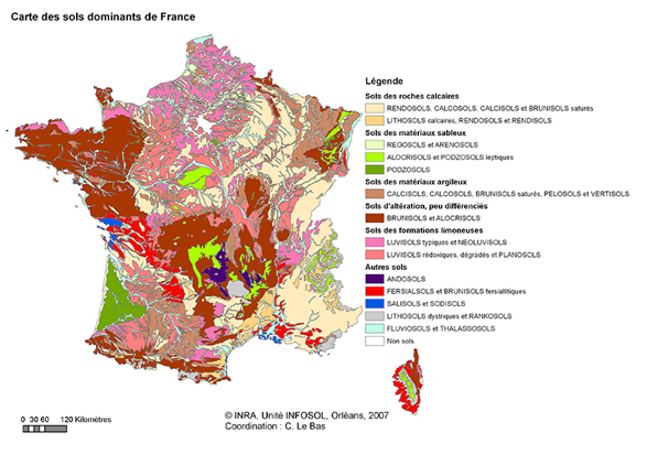
The difference in sediment type and age between the Landes Forest (sands from the Pleistocene) and the vineyards (weathered rock material from the Pyrenees mixed with Tertiary marine sediments) on the banks of the Garonne River does not only result in a very distinct landscape and land use, but is also well recognizable in the soil map of France.


