After the Tour de France we want to take you to Spain for the geology of the Vuelta a Espana that starts on Saturday 26 August in Barcelona. In general, there is a direct correlation between the geology of the Vuelta course and the winner of the stage. Stages leading through sedimentary basins – think about the depression where the big rivers now are, are for the sprinters.
Most of the stages in the Mesozoic and Paleozoic of Central Iberia are for the puncheurs, although there are a couple of nasty long ’puertos’ there. The climbers will have a field day in the Pyrenees and its western continuations in northwest Iberia, and in the Betic mountain belt in the south. A field day. Get it?
So vamos!
Iberia: a continent
Iberia is a continent. When geologists talk about ‘continents’, they don’t exactly mean ‘land mass’, but refer to the geological composition of the crust. There are two types of crust: oceanic and continental. Oceanic crust forms at mid-oceanic ridges and consists of rocks that cooled from magma. They have a composition of basalt. Continental crust is made at subduction zones. The top few kilometers of subducting plates were folded and stacked up at subduction zones. Also volcanoes formed above these zones. Much of the geology of Iberia shows such ancient, folded-up rocks. Iberia also has remains of these big volcanoes and their magma chambers.
Geologists make maps that show properties of the rocks that we find at the surface. There are several types of those, but a useful one divides the rocks according to their age. Younger rocks have simply experienced much less of Earth’s history than older ones. Sounds logical because it is. The older the rock becomes, the more geological ‘violence’ it may have experienced. So what do we mean by that violence in the geology of the Vuelta?
Plate tectonic ‘violence’
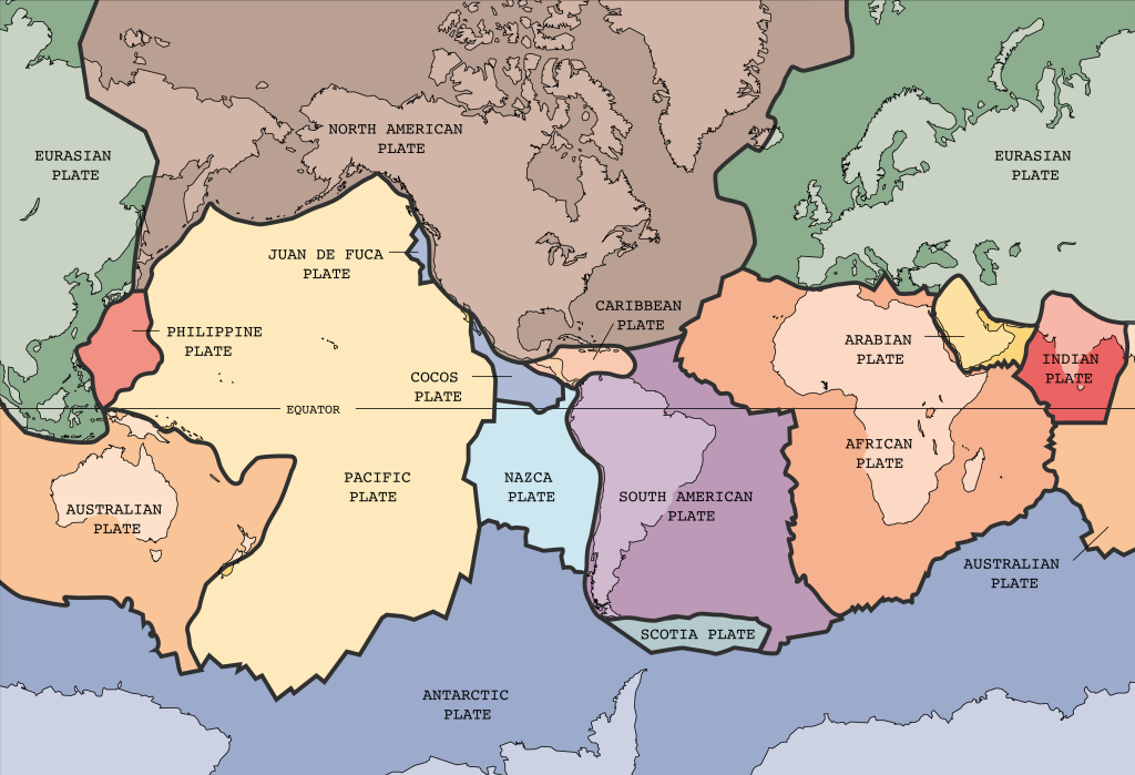
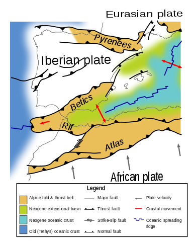
This ‘violence’ we mean is caused by plate tectonics. Geologists can spend hours talking about it but that’s nothing compared to the time scale we talk about. In the last 80 million years, Africa and Europe moved towards each other. Iberia was unluckily caught in the middle of all that tectonic force. This resulted in the formation of the Pyrenees between ~85 and 20 million years. Then there was the formation of the Betics-Rif mountain belt, mostly between ~50 and 7 million years and – last but not least – in the Central Iberian Ranges and the Iberian Massif between ~40 and 20 million years ago. The latter runs roughly east to west through central Iberia just north of Madrid. These motions caused steep relief which explains why there is so much climbing to do in the Vuelta. Poor sprinters.
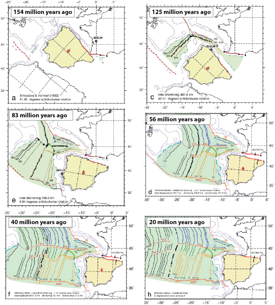
Before these big mountain building events, in the period from ~200 to 80 million years ago when the supercontinent Pangea broke up, large basins formed on and around Iberia. The continental crust of Iberia was mostly below sea level. During the heydays of Pangea, between ~270 and 200 million years ago, Iberia was a desert area in the heart of the supercontinent. It was mostly eroded. Before 270 million years ago, most of the continent of Iberia formed when the enormous landmasses of Gondwana (including Africa) and Laurentia (including North America) formed.
Neogene basins: let’s talk rocks
The map below divides the geology of the Vuelta eh we mean Spain into four main colors. The light yellow rocks are ‘Neogene-Quaternary’ sedimentary basins. These are topographic depressions surrounded by higher mountains where sediments have been deposited in ‘recent’ geological time. The Neogene started 23 million years ago but most of the basins are younger. The main ones are the river Duero, the Ebro, the Tajo, and the Guadalquivir basins. Sediments in these basins are mostly derived from erosion of the surrounding mountain belts, mixed with plant remains and some evaporation-related sediments in lakes. These Neogene basins have experienced only limited tectonic deformation: only in the south, in the Betic mountain belt that is located around the Africa-Iberia plate boundary, is there folding of Neogene rocks. For the rest, these basins are flat. The sprinters that dared travel to Spain will be elated.
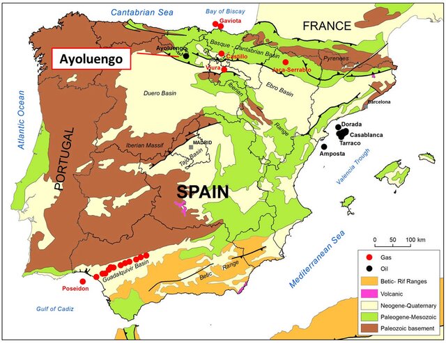
If you look carefully, you’ll also find three spots of pink on the map. One is located about 100 km north of Barcelona, the start town of this year’s Vuelta. Another is located about 250 km south of Madrid. The last one is located on the southeast coast, in the Betic range. These are regions of young volcanoes. The two in the north are ‘monogenetic’ volcanoes, which are similar to the ones in the Chaines des Puys of the Massif Central in France. The one in the south is related to subduction in the Gibraltar region. These volcanoes formed in the last few million years, and are the only ones of the Iberian continent.
Mesozoic limestones: Iberia as a Bahamas platform
Let’s scroll back to the colourful image. In green we see rocks that formed during the Mesozoic (the time of the dinosaurs, between ~250 and 66 million years ago) to Paleogene (after the 66 million year-old extinction of the dinosaurs and before the Neogene). They occupy much of eastern Spain and are widespread in the Pyrenees.
Most of these rocks formed in shallow seas that flooded Iberia and consist of limestones. These limestones contained reefs made by corals and other reef-building creatures. The shallow platforms are separated by deeper basins. Imagine the Bahamas as an example. The Mesozoic rocks have experienced the formation of the large mountain belts of the Pyrenees, the Central Iberian Ranges and Iberian Massif, and the Betic ranges. This means that along many climbs of the Vuelta, you will see white limestone layers in all imaginable directions. This is because they were folded due to the tectonic violence. The geology of the Vuelta right in front of you!
Paleozoic basement: an unhappy bunch caught between colliding continents
Finally, in brown are the oldest rocks of Iberia, They are more than 270 million years old but going back to more than 500 million years. They are mostly found in western Iberia and also in the Pyrenees. There, the Mesozoic limestones were either eroded away, or these parts of Iberia formed islands in Mesozoic times, on which the limestones were never deposited.
These Paleozoic and older rocks are genuinely unhappy. Let’s say they have been through a lot, like the peloton after three weeks around Spain. They are folded, broken, recrystallized, tortured, cooked, baked, molten, intruded by granites, overlain by volcanoes, shaken, and stirred. We call this the ‘basement’ of Iberia, which formed during the formation of the supercontinent Pangea.
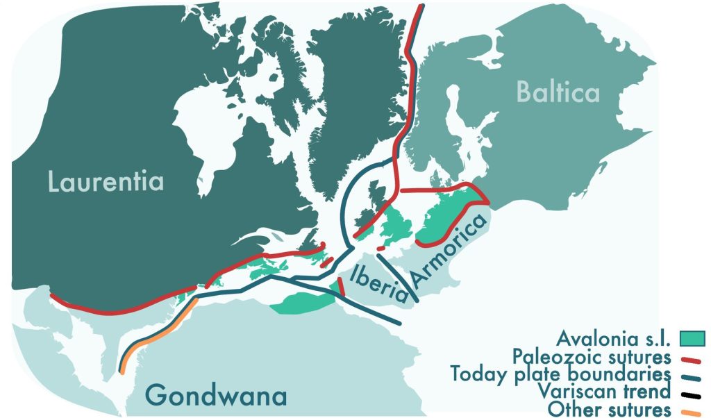
On the map below, which shows the position of the continents around 270 million years ago, you see what the position of Iberia was within this supercontinent. The white area to the east of Iberia-Armorica was mostly ocean (the Tethys Ocean), and to the north, west, and south, Iberia was surrounded by the continents that fitted together before the Atlantic Ocean opened.
Too many mountains
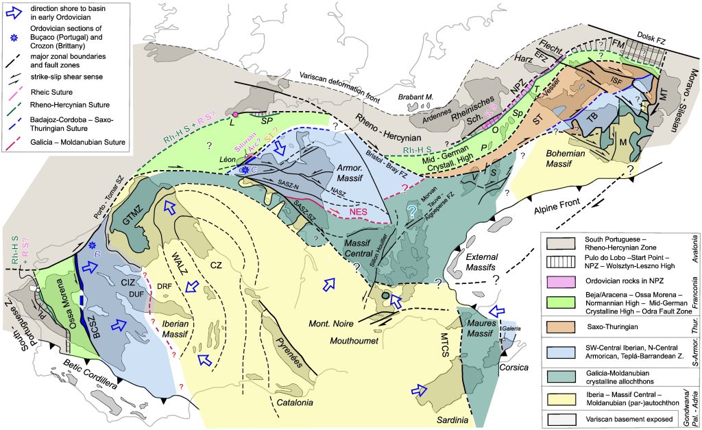
When Pangea formed, Iberia was not a ‘continent’ yet. It was a big mountain belt that consisted of offscraped rock slices and big volcanoes. It’s a bit like the Tibetan Plateau and the Himalaya today. This mountain belt was far larger than only Iberia. It ran from Mexico to Florida, along the Appalachians, through Iberia and Western Europe all the way to the Czech Republic.
This detailed map below of that mountain belt requires a bit of study. You see the outlines of Iberia, France, the British Isles, Corsica and Sardinia, and the front of the Alps. These are reconstructed in a position before the Atlantic opened. On that map, large belts are indicated that share a similar history. You will see that the belts of Iberia continue into France, and from there on to the east. And that those belts are strongly curved: Iberia was also in Pangea caught in the middle, had nowhere to go, and was squeezed together like a car wreck in a press…
Vuelta a España daily
While the riders ride their bikes and you marvel at the wonderful landscapes, we will keep you posted on nice geological and geographical phenomena that you will see on your screen when watch the stages! Our mission is to show geology is everywhere, especially in the bike races. So give us a follow at Twitter/X account @GeoTdF to not miss anything of the daily geology of the Vuelta.
-

Douwe is a geologist. He works as Professor of Global Tectonics and Paleogeography at Utrecht University. He investigates the plates, oceans, and continents that were lost to subduction. For this, he uses geological remains of these lost plates: rocks that are found in mountain belts all over the world, and subducted plates that can be seen in cat-scans of the Earth’s interior. Since 2021, he has been explaining the geology of pro-cycling races, including but not restricted to the Tour de France.
-


