It’s time for the geology of the Tour of Qinghai Lake. This year is edition 23. The race will be held from July 7 to 14, 2024. There are eight stages with a total distance 1,152 kilometers of racing. The route passes through Xining City, Haidong City, Hainan Tibetan Autonomous Prefecture, and Haibei Tibetan Autonomous Prefecture.
The race features a variety of stages, including flat roads, mountains, and hills, with an average altitude approaching 3,000 meters. And geology of course! The geology of this region in Northeast Tibet is truly fascinating. Here is a straightforward guide to the natural wonders you will be pedaling through. Let us take you on a tour of the geology of Qinghai Lake.
A Jewel of the Tibetan Plateau
Qinghai Lake is the largest saltwater lake in China. It measured 4,543 km2 in 2020. The lake is situated at an altitude of over 3,200 meters and reaches a maximum depth of 32.8 meters. The average depth is only 21 meters. It is like a shimmering blue gem set in a vast, high-altitude landscape. But what makes this place so special geologically?

There are some highlands surrounding the Qinghai Lake, which are made of Cenozoic sediments. Hence, through the sections of these highlands, geologists can study the evolution of Qinghai Lake based on the assemblage of sediments. Research shows that the lake basin drained out eastward into the Yellow River till the late Pleistocene when the uplift of the mountains cut off the drainage and made it a closed basin lake.
Fish
Since Qinghai Lake currently has no outlet for drainage, minerals are continuously brought into the lake by surrounding rivers. When the evaporation rate of the lake water equals the inflow from the rivers, the mineral content in the lake increases. Over time, this process has turned Qinghai Lake into a saline lake. The average salinity of Qinghai Lake is 12 grams per liter. Although the salinity of the Qinghai Lake is much lower than the average salinity of seawater at 35 grams per liter, it is still not suitable for drinking. Fortunately, the rivers around Qinghai Lake provide abundant freshwater resources for the surrounding people and wildlife.
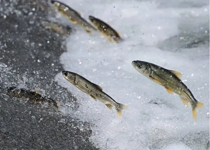
The most famous fish in Qinghai Lake is Gymnocypris przewalskii. The most interesting aspect is that every year from June to July, when the water temperature reaches suitable conditions, the Gymnocypris przewalskii leave Qinghai Lake and swims upstream along the rivers to their birthplace to spawn. After hatching, the young fish swim back to Qinghai Lake.
Tectonics
The Tibetan Plateau is often called the “Roof of the World. It was formed by the collision of the Indian and Eurasian plates. This powerful geological process started around 50 million years ago and continues today. It is still slowly pushing the land upwards. This ongoing tectonic activity is why the region is so mountainous and elevated. For this reason, this place has become a natural laboratory favored by geologists.
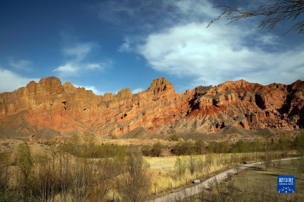
As you cycle around Qinghai Lake, you will notice layers of sedimentary rocks. These rocks were formed from sediments that settled in ancient lakes and seas millions of years ago. Over time, these sediments were compressed into rock layers, each telling a story of the environment at the time they were deposited. What is even more interesting is that in Guide, you can find sedimentary rocks with striking rhythmic red patterns, known as Danxia landform.
Stories from the ice age
During the last Ice Age, glaciers covered much of the Tibetan Plateau. As the ice moved, it carved out valleys and shaped the landscape in distinctive ways. Even though the glaciers have long since melted, you can still see their impact in the smooth, rounded valleys and the presence of glacial deposits.
But we go from cold to hot. The area around Qinghai Lake is also known for its hot springs and mineral springs. These are the result of geothermal activity beneath the Earth’s surface. As groundwater is heated by the Earth’s internal heat, it rises to the surface. This creates these warm, mineral-rich springs. They are not only geologically interesting but also popular spots for relaxation!
Fossils
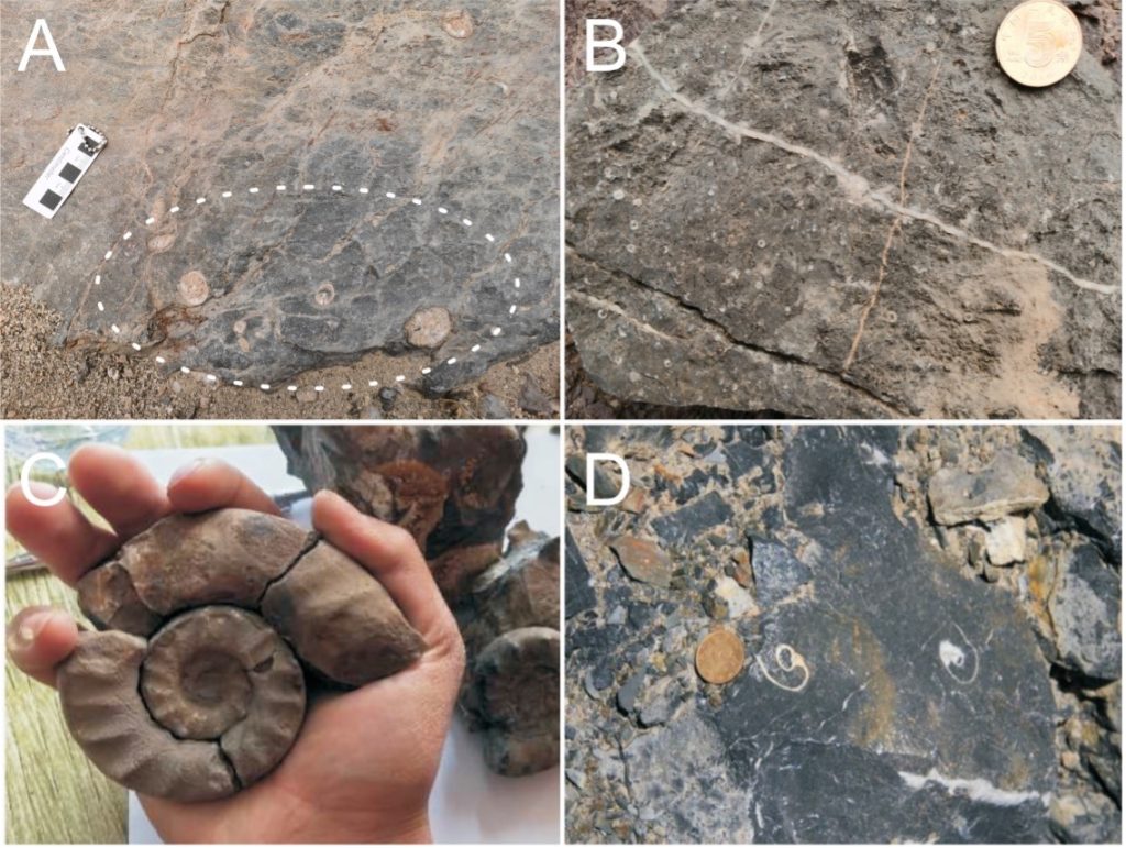
Keep an eye out for fossils embedded in the rocks. For example, in Carboniferous-Triassic strata you can find lots of fossils such as coral, brachiopod, gastropod, sea lily, etc. These are remnants of ancient plants and animals that once lived in the area. They offer a glimpse into the region’s distant past, when it was a quite different environment from the high-altitude, cool climate you will experience today.
Living landscape
Finally, remember that the geology of Qinghai Lake is not static. The same forces that shaped this incredible landscape are still at work. Earthquakes occasionally rumble through the region. The lake’s water levels change with the seasons and climate variations. It is a living, dynamic system that continues to evolve.
As you cycle around Qinghai Lake, take a moment to appreciate the geological marvels around you: from towering mountains to ancient rock layers. Every turn of the pedal takes you through millions of years of Earth’s history. Enjoy the ride and the natural wonders that make this race truly unique!