In 2020 a catastrophe hit the region where we race today. The start of this penultimate stage is in Nice. The riders pass the Col de Braus for the 27th time in Tour de France history. They also climb the the Col de Turini. After that climb the riders arrive in the Vésubie valley in the Mercantour-Argentera Massif. This is one of the eleven national parks in France. A catastrophe that happened in October of 2020 in this valley gives us the opportunity to present the geomorphic processes shaping Alpine valleys such as the Vésubie. We also look at the future and how to prevent this from happening again.
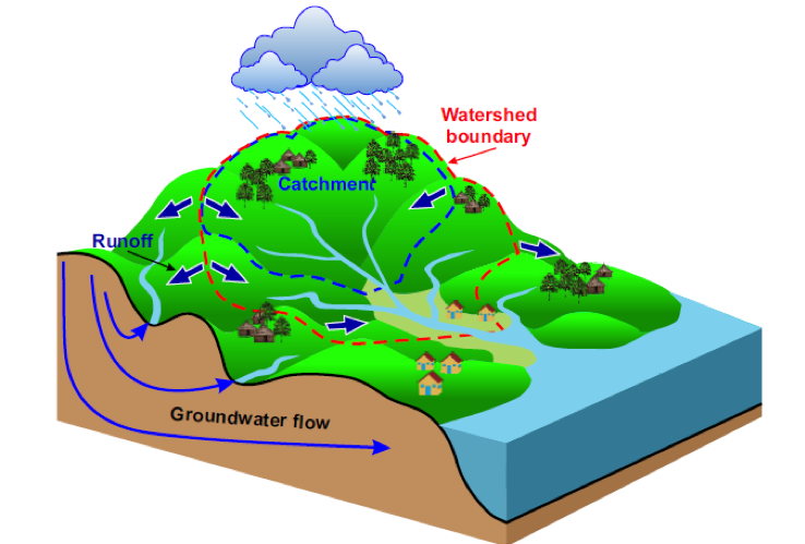
In this blog, we shall use the term catchment basin (or catchment). The catchment basin is a geographic delineation, which represent the area drained by a river and its tributaries.
Rocks of the Vésubie valley
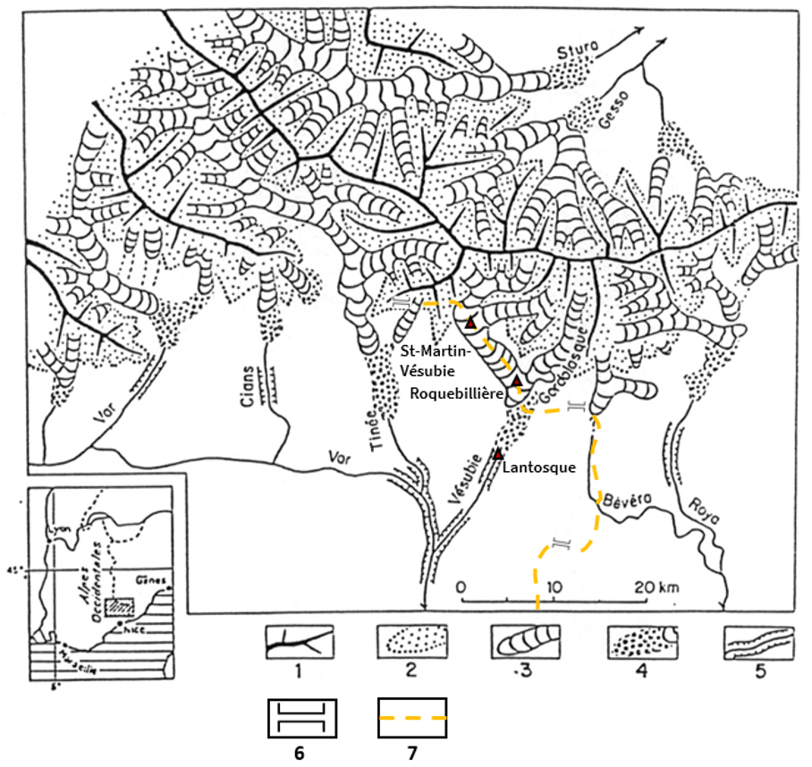
The physical characteristics of the Vésubie catchment are typical of those of the French Alps. It is a quite steep and narrow valley composed of three distinct rock formations. The upper parts of the catchment (upstream of Roquebillère) are mainly composed of crystalline rocks. They are most likely related to the Hercynian orogenesis (420 to 300 million year ago).
Sedimentary formations are more recent. Here you find limestones, marls and sandstones. They are abundant in the lower parts of the catchment (Roquebillère and downstream). The presence of fossilised marine microorganisms tells us that these rocks date from the Jurassic period (200 to 145 million years ago). It attests of a prehistoric sea. Their alternations, known as ‘black flysch’, will be particularly visible on the roadsides on the Col de Turini.
The third rock formation corresponds to quaternary (2.58 million years ago to today) surficial deposits. These are rocks inherited from the glacial activities that occurred during the last cold periods of the Pleistocene epoch. Indeed the Vésubie valley was glaciated.
Cold times
It may sound surprising but glaciers were present in southern valleys of France. We know this because glacier dynamics leave characteristic imprints upon the landscape such as erratic blocks. We saw this on stage 14 of the TdF 2023. These large boulders standing in the upper part of the Gordolasque valley attest of ancients glacial activities. Their actual location cannot be explained otherwise than being deposited during a glacial retreat. Additional clues testifying to past glacial activities are present in the landscape in the form of sediment left by glaciers. In Roquebillère, which comes after descending the Col de Turini, near the confluence of the Gordolasque (left bank tributary of the Vésubie) and the Vésubie, we see moraine deposits at some locations.
Moraines are typical glacial formations made of rock debris that was once transported by a glacier. In our case, moraines in Roquebillère date most likely from the last cold period known as the Würm. As the glaciers underwent their last stage of retreat during the Würm, moraines deposited and stabilized. In the same time, meltwaters and torrents also contributed to fill the valley floor with rocks.
Like many valleys of the Northern French Alps, the multiple stages of glacial expansion and retreat during the Pleistocene have structured the shape of the Vésubie valley. The glacial deposits that have coated the valley floor have been partly and progressively removed by fluvial erosion as the vegetation and the humans have conquered these new spaces. Erosion over thousands of years explains why these glacial formations are now very patchy in the valley. Still, this glacial heritage turned out to be decisive during the 2020 flood.
A catastrophe named Alex
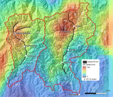
On 2 October 2020, a massive Mediterranean climatic episode generated by a storm coming from the North Atlantic, called the Storm Alex, occurred over the Tinée, Roya and Vésubie valleys. The rare intensity of this event led to dramatic casualties, causing the death of 10 people and leaving eight missing. It transformed the landscape of the valley floor, destroying houses and infrastructures.
According to Météo France, this episode reached rainfall levels up to respectively 600 and 500 mm in 24 hours above the Roya and Vésubie catchments. This almost represents the annual rainfall on those valleys (see Figure 2). This amount of rainfall statistically only happens once every 1,000 years!
Sediment catastrophe
In addition, extraordinary geomorphic response of the tributary torrents made it even worse. The rainfall has massively remobilized surficial deposits in the tributaries, and in particular, those inherited from the cold periods. The tributaries have been the stage of numerous landslides and intense torrential processes, such as bank erosion, bedload and even debris flows.
It resulted in a significant amount estimated roughly at 1.5 Mm³ of sediment transported downstream to the Vésubie River. To compare, think of 400 Olympic pools filled with sediment! All these sediments, coupled with the hydraulic power, contributed to the destructive power of the Vésubie river during the storm, washing away many of the alluvial terraces in the valley floor. In some places there were homes and other buildings.
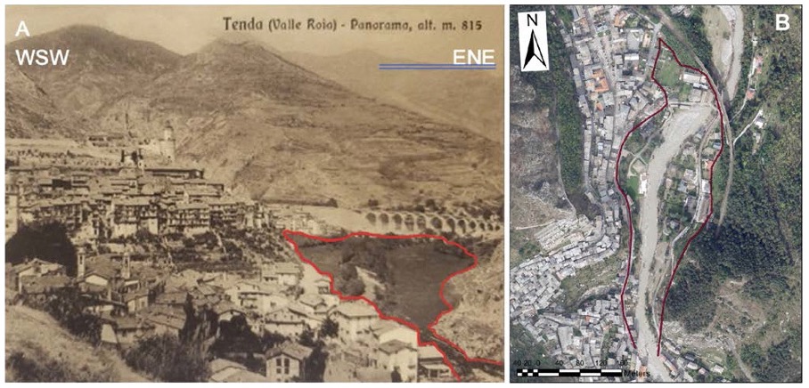
In order to get an idea of the river’s destructive power, it is worth noting that the mean active channel (the space in which the river can flow freely) increased from 19 meters to 79 meters after the storm. Locally, alluvium deposits reached up to 10 meters! This led to an unprecedented morphological evolution of the river. The Vésubie River has changed from a single thread channel to a braided pattern, showing multiple channels of water intertwining in a gravelly corridor.
Risk management
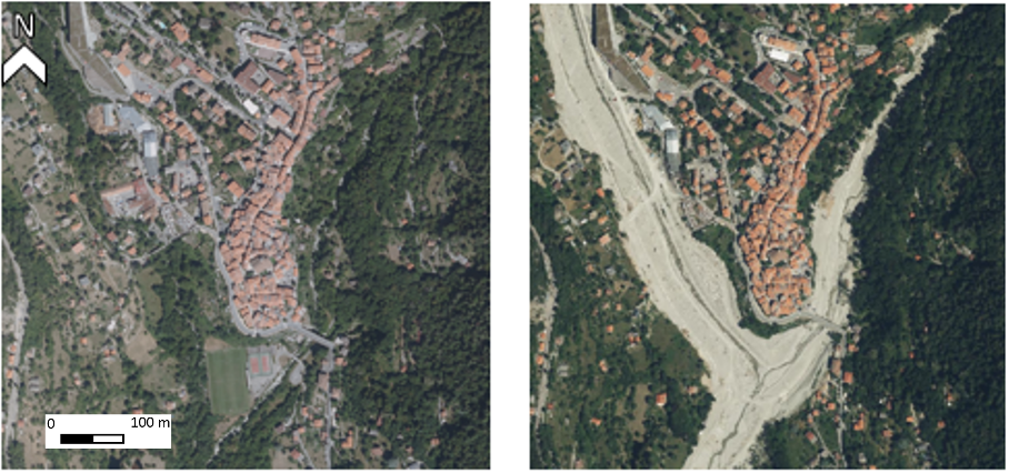
You can easily imagine that this event was striking for the people of the valley but also for any inhabitants in these same kind of valleys. It is a reminder of our vulnerability to natural hazards, which, nowadays, people tend to forget. As we can see on pictures in the image below, in the adjacent Roya valley, many recent constructions are located in the floodplain, which by definition is subject to flooding.
Regarding the safety of the inhabitants of the Vésubie valley, flood risk management has once again become a major concern for the authorities. Indeed, sediments that are now stored in the river worry as they could be remobilized by an event. Because the costs of these reparation are huge, and because of the context of urgency, this situation challenges local public policies related to the risk management strategy.
The future
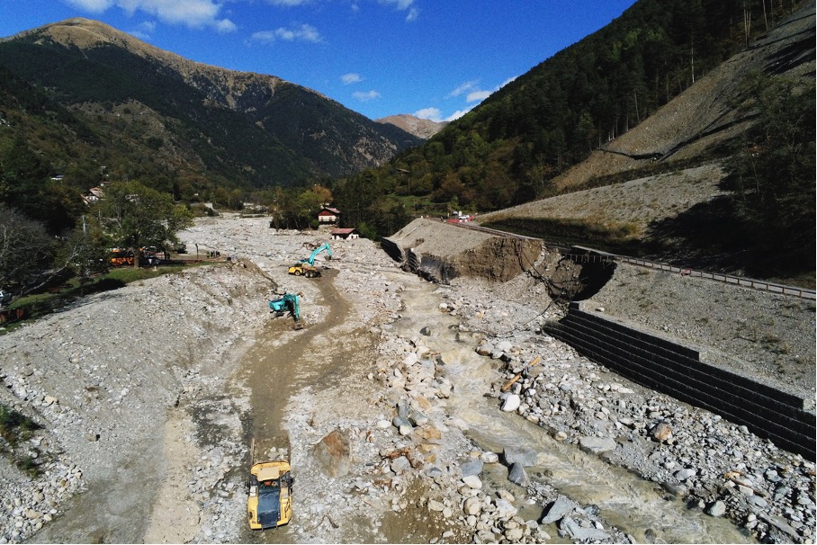
The strategy recommended by the experts was to maintain this newly-created space of freedom for the river. It gives the river room to wander as floods occur. Nonetheless, this strategy is quite restrictive for the local authorities. It requires relocating stakes, strengthening the banks when they cannot be relocated, and to absolutely avoid building infrastructures in the riverbed. Unfortunately, on 19 October 2023, another storm, named Aline, hit the catchment. Not as big as Alex, but rather important to cause new damages. The high amount of sediment deposited during Alex storm was remobilized leading to the destruction of some newly built riprap and infrastructures after the Alex storm.
For the inhabitants of the valley, who had to face two major floods in four years, it raises the concerns that this kind of event happens more and more because of climate change. The Alps are highly affected by climate change. GIEC estimates that it warms two times faster than in other region. However, because climate variations are quite local and the destructive characteristic of a flood rely on multiple factors (such as the availability of sediments), it is not easy to estimate if this kind of event will be more frequent in the future.
NB: Blogs in other languages than English are all auto-translated. Our writers are not responsible for any language and spelling mistakes.